Dear reader: This article contains links to products and services that I may be compensated for, at no extra cost to you.
The Pisac ruins are some of the most important Incan ruins in Peru’s Cusco region and the Sacred Valley, along with the ruins at Ollantaytambo and more remote Huchuy Qosqo.
They are a great addition to any Machu Picchu visit. I especially recommend visiting these and other Sacred Valley attractions BEFORE Machu Picchu so you can build up to the most famous one – you may even find you enjoy these more than Machu Picchu, as they are far less crowded!
When I recently spent four days exploring Pisac, the ruins were of course at the top of my list. I didn’t go with a guide, so I did a lot of advance research and planning beforehand. However, once I got there, I found that a lot of the information, maps, and guides online were outdated, especially regarding a whole section of the site that has been closed for years due to a landslide. I had to do some backtracking at the site as a result.
That’s why I’ve decided to put together this new guide to Pisac ruins based on my personal visiting experience. Below I’ll provide extensive instructions and photos to guide you on your visit, especially for those who’d like to forgo a guide and visit the ruins on your own.
Table of Contents
Pisac Ruins Fast Facts
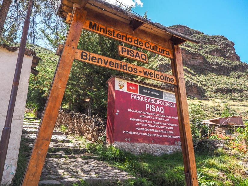
- Local Name: Parque Arqueológico Pisac (Pisac Archaeological Park – Peruvians prefer to say this over “ruins”). Pisac may also be spelled Písac or Písaq.
- Elevation: 3350 m/ 10,990 ft. This is 380 m/1246 ft above Pisac town, 920 m/3018 ft higher than Machu Picchu, and 50 m/164 ft lower than Cusco. However, the highest point of the ruins is actually higher than Cusco (see my favorite things to do in Cusco here).
- Location: 19 km (15-20 min drive) north of Pisac town, or 43 km (1 hr 10 min drive) north of Cusco.
- Visible from town? Mostly no. Much of the Pisac ruins are concealed behind a mountain that rises north of Pisac town. From the town, you can see some of the terraces, which are considered part of the archaeological site, but the full extent of the site won’t be revealed until you get there and continue exploring it.
- Age: Uncertain, but major additions were made around 1450 by Pachacuti, who also built Machu Picchu.
- Number of Terraces or andenes: around 500
- Entrance fee: 130 soles as part of the Boleto Turistico (16 sights included, valid 10 days, can purchase on site or here online) or 70 soles as part of the Partial Boleto Turistico (4 sights included, valid 2 days)
- Opening Time: 7 AM to 5 PM
- Best Time to Visit: As early as possible, so you’ll have the ruins entirely to yourself like I did! Then you can make it to Pisac town for lunch – see my recommended Pisac restaurants.
- Secret Tip: The ticket offices at the top and bottom only open at 8 AM. If you enter between 7 and 8 AM, the guard will let you in for free.
- Time Needed to Visit: 1-2 hours for short visit (starting and ending at upper entrance, as tours like this one or this one will do), 2-4 hours for long visit (starting at upper entrance and walking back to town), 4+ hours for longest visit (walking up from town and walking back down)
Pisac Archaeological Park Introduction
The Pisac ruins, or Pisac Archaeological Park (locals prefer this term, since “ruins” suggests the sight is no longer sacred or important) are some of the most significant Incan ruins in the Sacred Valley. This valley is created by the Urubamba River, which flows toward and then around three sides of Machu Picchu.
It is said that Pisac’s ruins are the 3rd most important in the Sacred Valley, after Ollantaytambo and Huchuy Qosco. However, Huchuy Qosco is quite difficult to visit, and I personally found Pisac’s ruins to be more visually stunning that those at Ollantaytambo, mainly because of their higher, mountain-top location.
Like many Inca sites, Pisac is believed to have served a mishmash of functions: as a residence, observatory, military station, and ceremonial site. Notably, Pisac has an Intihuatana or Intiwatana (a carved ritual rock). You may recognize this word from the more famous one at Machu Picchu, but the one at Pisac was actually found and named first.
How to Visit Pisac Ruins
Pisac is the easternmost town and ruins in the Sacred Valley – in other words, it is the closest to Cusco but furthest from Machu Picchu. Because of this, and also because Pisac is lower than Cusco, I thought it made a lot of sense to start my whole visit to the region in Pisac.
After flying into Cusco, I went directly to Pisac, which is hundreds of meters lower, to acclimatize for my trip and adjust to the altitude. I spent four days in Pisac, one of which I used to visit the Pisac ruins. If you do the same, I recommend not doing Pisac ruins on your first day or two, as you may experience some mild altitude sickness like I did, even in Pisac. Visiting the ruins is rather strenuous, even if you start at the top.
After Pisac, I worked my way down the Sacred Valley, including my 4-day Inca Trail hike to Machu Picchu. Then I went to Cusco, the highest place, at the end of my trip.
A lot of people do the opposite, starting in Cusco first. I don’t recommend this. Because Cusco is quite a bit higher, you are more likely to experience altitude sickness there. It’s also a bigger, noisier, more intense city, so you are more likely to experience culture shock there.
I realize most people don’t have as much times as I spend in the Cusco and Sacred Valley region (I spent 3 weeks!) In fact, the majority of visitors visit the Pisac ruins, and perhaps Pisac town for its famous Sunday market, as a part of a Sacred Valley day tour like this one or this one.
This guide is intended more for people spending more time there and visiting on their own. But even if you’re planning to come on a tour, the below info will give you a lot of context for what you are going to be seeing at Pisac ruins.
Getting to Pisac Ruins
There are several options for getting to the Pisac Archaeological Park, which I’ll cover in individual sections below.
As Part of a Tour
Most people visit Pisac ruins as a part of a guided tour. Popular tours like this one typically start in Cusco, stop at Pisac ruins first, have lunch in Urubamba, then return to Cusco via the weaving village of Chinchero. Others like this one do it in reverse and include a few more stops: starting in Cusco, then Chinchero, Moray ruins, Salineras Salt Mines, Ollantaytambo, and finally Pisac at the end.
When choosing your tour, consider that almost all ruins are virtually empty first thing in the morning, then get bombarded with people from around 10 AM onwards. So if you care most about Pisac, try to choose a tour that does Pisac first.
If you visit Pisac on one of these tours, your visit will start and end at the upper entrance to the ruins, which is a 20-minute drive from Pisac town.
By Return Taxi
The shortest and easiest (but most expensive) way to visit on your own is to take a taxi from Pisac town, ask the driver to wait for you, and then take the same taxi back down.
One-way taxi prices from Pisac town to the ruins used to be set at 25 soles (which is already expensive), but when I visited I found that 30 to 40 is the new norm. So for a return taxi ride, with the driver waiting for you while you explore the ruins, the price is likely going to be 50-60 soles or higher.
Ask your hotel to arrange one for you for the best chance of getting a reasonable price. If you have good negotiation skills or you want to arrange one on your own, the best place to ask is on either side of Puente Pisac, the main bridge into town, where most buses, colectivos, and taxis stop.
Note that if you start at end your visit at the upper entrance, you probably are only going to be visiting about half of the ruins (i.e. the “short” route that I’ll describe below) and asking the driver to wait about 1 hour for you. You could visit more of the ruins, but then you’d need to ask the driver to wait even longer, which will probably cost even more.
Taxi Up and Hiking Down
What many DIY visitors do, myself included, is take a taxi to the upper entrance (go as early as you can to have the ruins all to yourself!), then hike all the way back to Pisac town through the ruins.
This is my most recommended option for several reasons: you arrive at the ruins early before anyone else does, you get to see ALL of the ruins, you enjoy amazing views looking down on Pisac town toward the end, and your hike will be mostly (but not all!) downhill.
As I mentioned above, the set price for a one-way taxi from Pisac town used to be 25 soles, but now 30-40 is more common. I booked mine through a shop near Puente Inca, and although they had 35 soles written on the wall, I negotiated it town to 30.
In total, it took me four hours from arriving at the ruins to getting back to Pisac town this way. However, I visit quite slowly, taking lots of notes and pictures. If you move quickly, you could probably do it in 2-3 hours.
Hiking Up and Back Down
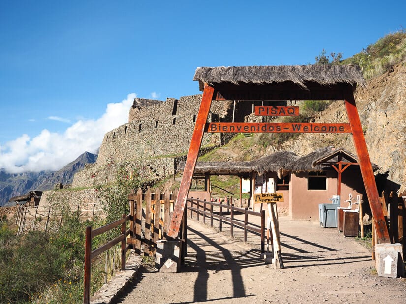
This is the longest, by far most strenuous, but also cheapest option for visiting Pisac ruins. From the northwest corner of Pisac’s main plaza (Plaza Constitución), follow the street going north/uphill. After a few blocks, you’ll reach the entrance sign to the ruins.
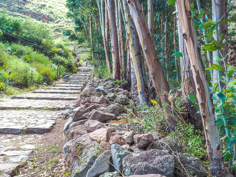
A few more minutes up this cobblestone path, with eucalyptus forest on the right, you’ll reach the ticket gate, where you’ll need to show or buy your Boleto Turistico. Note that if you pass this point before 8 AM, there is usually no one in the office and nothing stopping you from passing through without a ticket. So you could potentially visit the ruins totally for free!
From there, you’re looking at a pretty strenuous, uphill hike through terraced hillsides just to reach the lower end of the ruins (about one hour). Another hour of (mostly uphill) hiking will take you through the various ruins to the main area at the top, where the upper entrance is.
From there, you can backtrack and hike back to town (another 2 hours) or take a taxi down if you can find one at the parking lot there (that’s a big IF).
One downside here is that by the time you reach the main ruins area at the top, it’s already going to be busy with tour groups. That’s why I recommend taxiing to the top first, to enjoy the ruins crowd free, then hiking back down.
Maps of Pisac Ruins
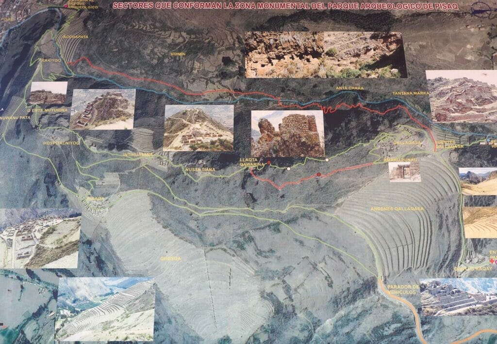
The above map is posted at the top and bottom entrances of Pisac ruins, but it’s a little confusing. Please allow me to walk you through it:
Pisac town is at the top-left corner. The main (Upper) entrance to the ruins is the red cross at the bottom right. After entering and seeing the incredible view of the terraces, you’ll be going up the green line to Fuentes Qallaqsa (Ceremonial Fountains) and doing the small green loop around Qallaqsa (Military Zone). From there, short visitors will probably go back to the entrance (red cross) and leave.
For longer visitors (those walking back to Pisac), after the small loop around Qallaqsa, they will follow the upper green line (not the lower red one, which is currently closed due to landslide) left to Llaqta Qawarina, Nusta Tiana, and Intihuatana. From Hospitanilyoc, the path will veer downhill for the final descent to Pisac town.
Don’t worry too much about all these names yet – I will cover all of these places in great detail in the self-guided tour below. Use this map as a reference as you read along!
You can ignore the lower orange and green lines, and the upper red and blue lines on the map. These are routes that I don’t recommend because they actually miss most of the ruins.
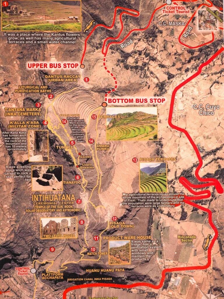
Here’s another useful map I saw posted in a shop. This one shows the driving route in red from Pisac town to Pisac ruins main (upper) entrance, with Pisac town at the bottom left.
Most visitors will alight at “Upper Bus Stop”, which is the main entrance, and this is what I strongly recommend. From circle #1 (the entrance), the self-guided tour I’ll recommend below will proceed to 2 (Ceremonial Fountains), 14 (Amaru Punku or Sun gate), 4 (Qallaqsa or Military Zone), then the optional 3 (Cemetery).
The section from 14 (Amaru Punku) to 5 (Tunnel) to the Gazebo is NOW CLOSED due to a landslide several years ago. So those walking down to Pisac town will need to walk from 4 to 6, 7, and so on, finally ending at “Control Ticket Tourist” at the bottom left, the Lower Entrance to the ruins, just a few blocks above Pisac’s main plaza.
Another pretty decent map can be found here. It was created by a website that sells Machu Picchu tickets. However, the map is a little old, because it doesn’t indicate that the route between Amaru Punku and Llaqta Qawarina is closed or even show the new correct route. This is the map that caused me to get disoriented until I figured this out and had to backtrack a ways.
I also used GoogleMaps while exploring the ruins. A few of the main sights at Pisac ruins are marked on it (like Pisac Q’allaqasa, Inti Watana, and Pisaqa Old Town). However, several sights are not, nor is the new route between the Military Zone and Intihuatana. Moreover, my Internet signal sometimes didn’t work up there.
Lastly, I used this map on AllTrails, which was not ideal, but it helped me for finding my precise location at any time. I have a paid AllTrails account, which means I can download maps and use them even when offline. The GPS always shows exactly where I am on the map. I highly recommend this for any serious/regular trekkers.
The problem is that the AllTrails route here is not one that I would personally recommend. It somehow manages to do a huge circle around the archaeological site, without visiting most of the ruins! Their suggested route starts in town then walks up through the river valley behind the ruins (instead of through the terraces and ruins themselves). Reaching the top of the site, it then circles down to the very bottom of the ruins for coming back. These are essentially the top and bottom routes in the first map above that I said I don’t recommend.
However, the map is still useful because it actually shows the path I do recommend as dotted lines in the middle.
Pisac Ruins Self-Guided Tour
Now I am going to walk you through the ruins as you would encounter them if you start your visit at the top, which is my most recommended way. If you’re hiking up from town, you’ll have to read this guide in reverse.
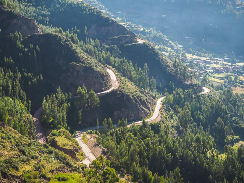
Driving Up and Arriving
The drive from Pisac town to Pisac ruins takes 15 to 20 minutes. On the way, you first pass through the lovely rural area just east of Pisac town, where several hippie-oriented hostels and lovely wasis (guesthouses) are located, including Wolf Totem, the guesthouse where I stayed (see on Booking / Agoda / TripAdvisor / HostelWorld).
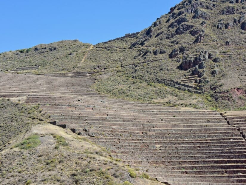
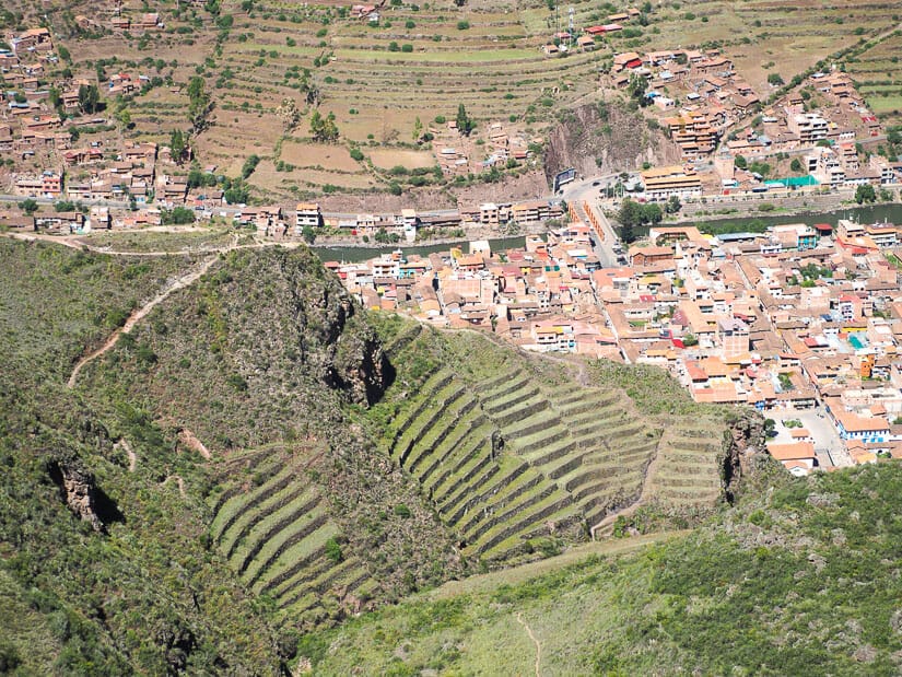
Around halfway up, you’ll actually get some amazing views of the largest sets of terraces at Pisac ruins. They will be on the left side of the car. If the driver is willing, ask them to stop at Mirador Pisac (Pisac Viewpoint, located here), which offers the best view. You’ll be viewing the terraces straight on (see photo above), whereas when you arrive at the ruins, you’ll be viewing them from the side or from above.
A few minutes before arriving, you’ll drive past the ticket checkpoint. This is where you’ll have to show or buy a Boleto Turistico. If you’re arriving before 8 AM like I did, there will be no one there, and you’ll just drive through.
At the top, you’ll arrive at a small parking lot, entrance gate, and some ruins will be visible just beyond (see photo below). When i arrived here at 7:30 AM, there was a single guard at the entrance. I was actually planning to buy my ticket at Pisac ruins since it was the first sight on the Boleto Turistico I was visiting on my Sacred Valley trip.
But since the ticket office we’d already passed hadn’t been opened, the guard just let me enter without a ticket! probably there are so few people who show up this early (I was literally the only person there for over 30 minutes) that they don’t even care or bother.
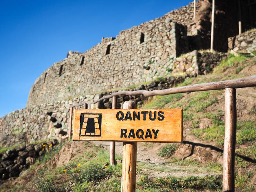
Qantus Raqay and The Epic View
Like at most Incan sites, your entrance to the ruins will be a dramatic one. This was almost always intentional.
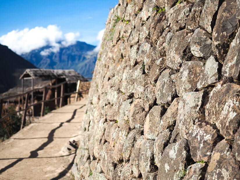
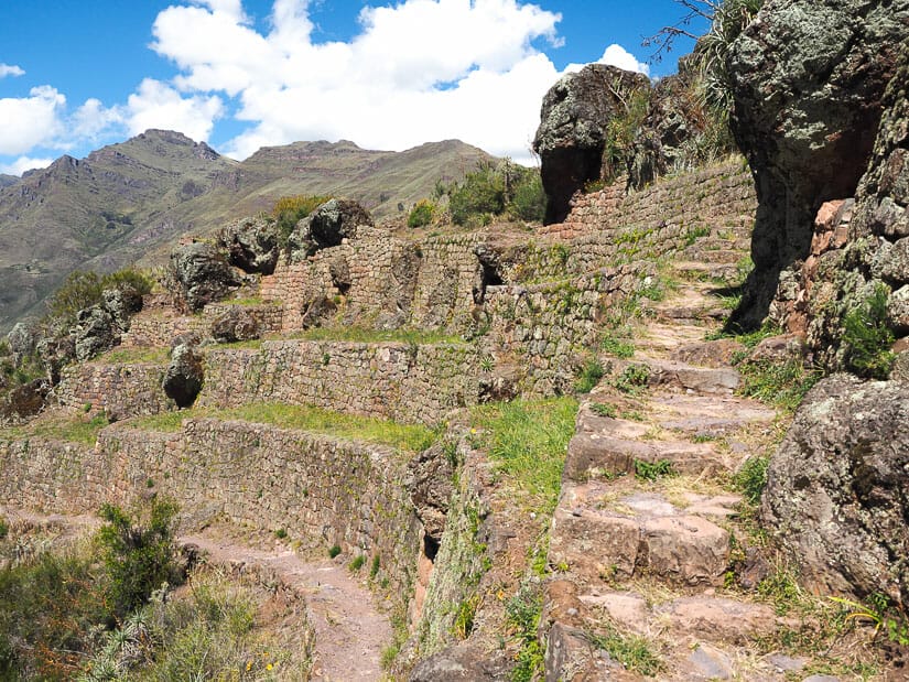
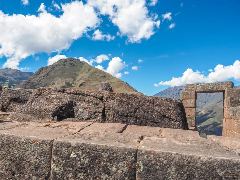
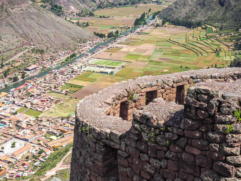
Just after passing through the entrance gate, you’ll find an impressive, 4-tier, rounded stone building to your right called Qantus Raqay (also spelled Kanturaqay) or the “Upper Urban Zone”. This was a residential and military structure for watching over the northeastern entrance to the complex. The path circles around the tower’s rounded base, with impressive stonework.
At the end of it, an arrow points left down a small staircase to a platform with ruins of several small buildings. Make sure to go down these stairs. Walk through these ruins to the edge of the platform, where an incredible panorama or the Pisac Archaeological Park will open up before you.
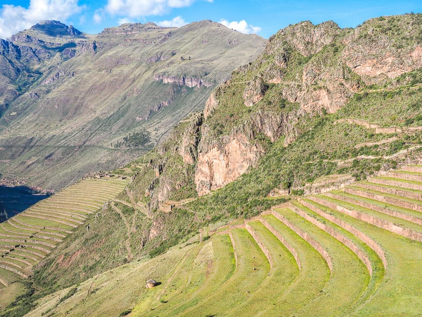
I counted 21 huge terraces before me (the ones on the right side in the above picture), with another 60+ terraces in the set further away (left side – they go down much further than what you can see in the picture).
At the top of those distant terraces, note Pisaqa Old Town ruins, which we’ll be visiting much later.
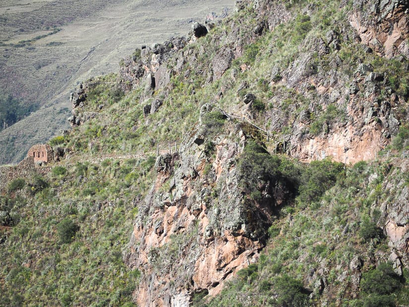
On the rocky mountain directly across in the picture, note the original path going across the upper portion of it. This is the original path for visiting the ruins, connecting the Military Zone and Intihuatana, which I’ve mentioned above is now closed. Instead, you’ll be walking OVER that mountain, for those doing the longer route to Pisac town.
Looking to the right and up, above the 21 main terraces, you’ll see the ruins of the Military Zone, which we’ll be visiting shortly.
Along the Terraces to the Ceremonial Baths
After spending some admiring the view, you’ll head to the right and rejoin the original path. You’ll find there are two paths running along the top of the terraces, an upper and lower one.
Take the lower one, which has a sign saying “Entrada/Entrance”. The upper path is for those exiting the site.
The epic views never end as you walk along the top of the terraces toward the Military Zone.
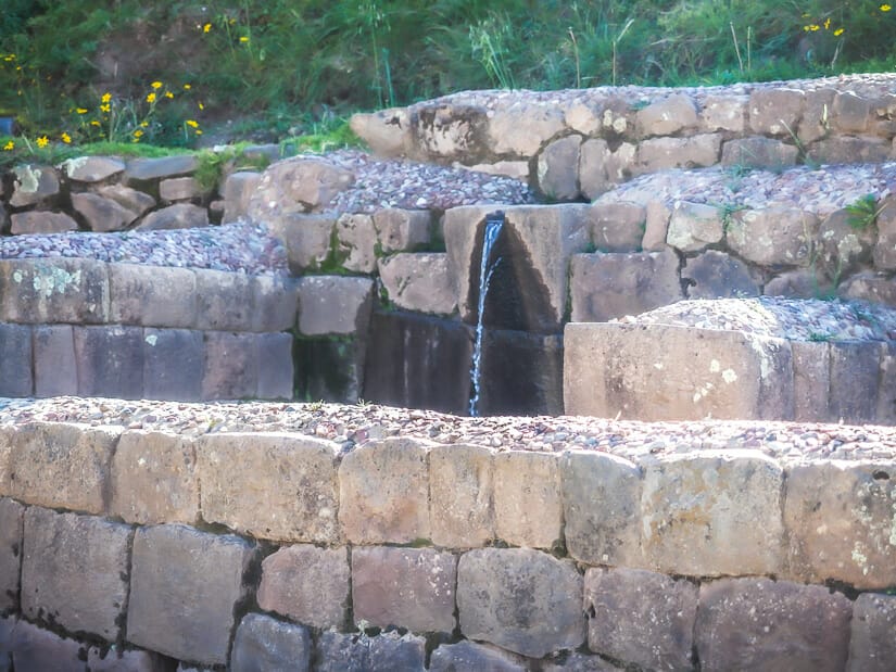
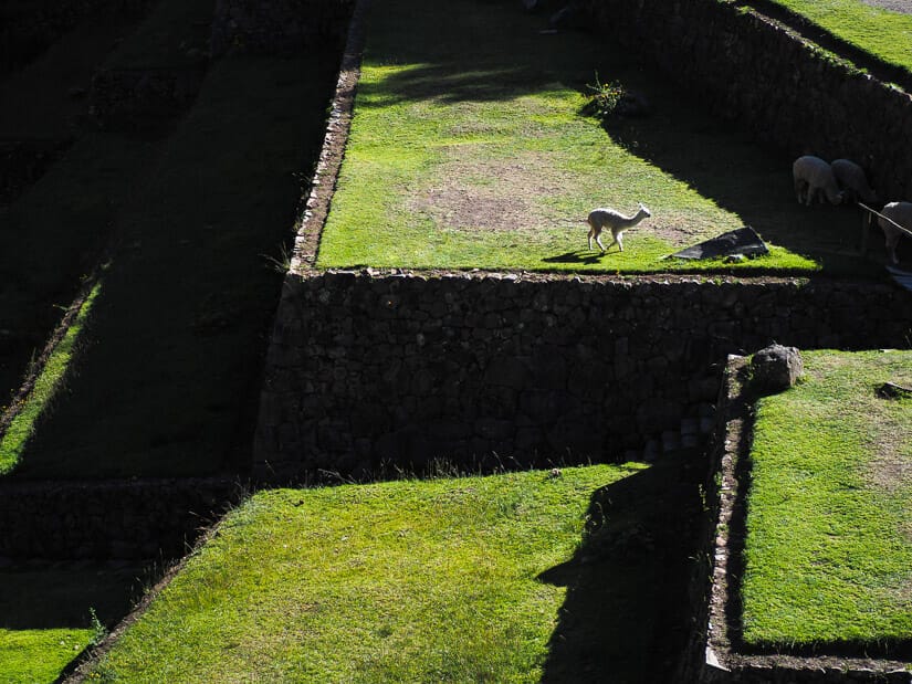
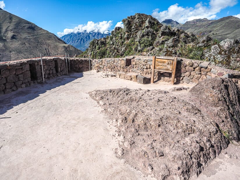
At the end of the path, when you reach an intersection with several signs, don’t miss the comparatively smaller and inconspicuous Ceremonial Fountains (Fuentes Ceremonial or Liturgical Baths) on the right. There are four ritual fountains/baths here with water still running through them.
From the baths, a sign points to the right to the only restrooms inside Pisac ruins. To reach them, you’ll pass some peaceful terraces where I saw several llamas grazing during my visit.
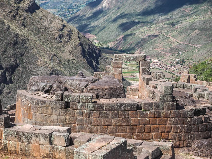
Military Zone (K’allaq’asa) and Amaru Punku (Sun Gate)
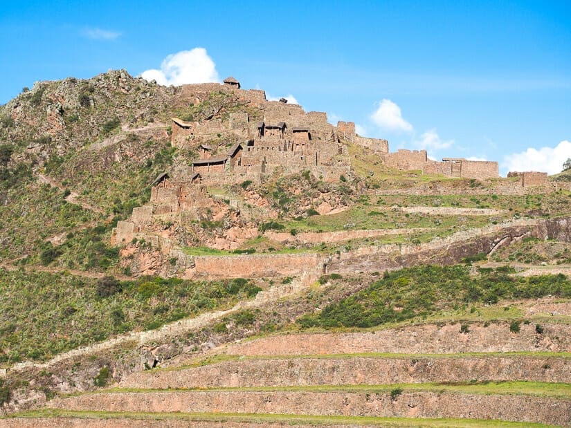
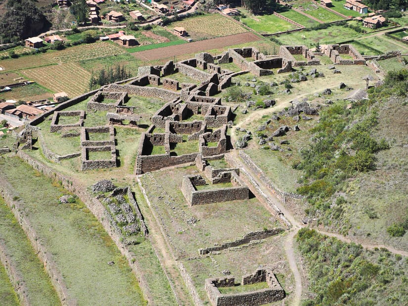
The most prominent collection of ruins at the whole site is the Military Zone or K’allaq’asa/Qallaq’asa, sometimes also called Hanam P’isaq or “Upper Pisac”. This is another residential and military area, with numerous houses, storehouses, and lookout towers.
These ruins cover a hill, including the highest point of any of the main ruins at Pisac (3514 m, which is higher than Cusco!)
There are a few different ways to tackle these ruins. One is to go straight in and up past a small management building. The sign pointing this way says “Camino a K’allaq’asa” (path to K’allaq’asa). This is not a bad option, and it’s what I did first, but I’ll give another option below that I feel is better.
The route will loop counter-clockwise around the back of the Military Zone, where you’ll have views of a small river valley where an Inca cemetery called T’antana Marka was found. More than 10,000 human remains and mummies were found here, making it the largest of any known Inca cemetery! The path will then climb up to the highest point of the ruins (which I’ll cover below).
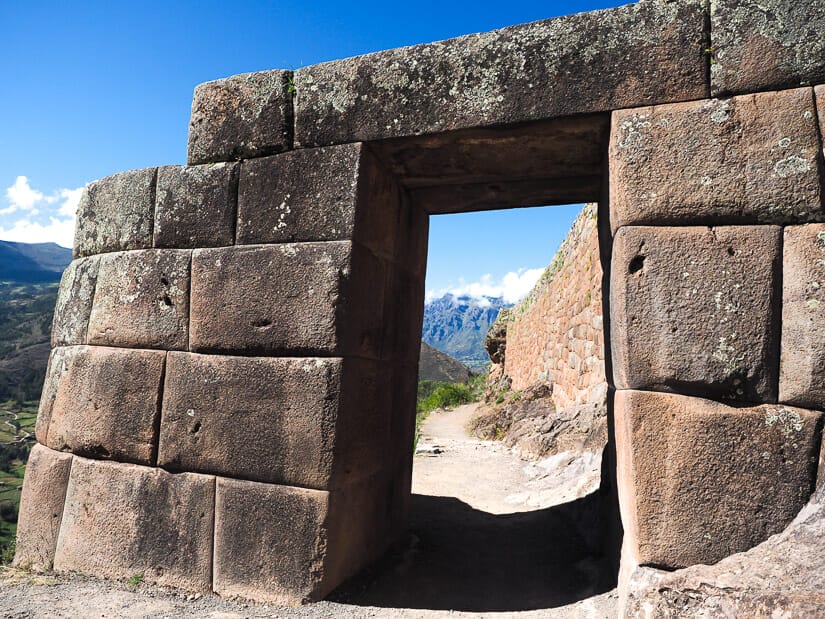
However, I actually recommend the traditional entrance. From the intersection with many signs, you’ll take a left, following a sign pointing to “Camino P’isaqa” and then another sign pointing to “Amaru Punku”. Going this way will be more like a clockwise loop around the Military Zone.
Amaru Punku, or Sun Gate, is the traditional entrance to the site, just like the famous entrance gate at Machu Picchu. I recommend going through it first because that just feels more dramatic. It will also avoid some steep backtracking for those planning to walk all the way down to Pisac (I learned this the hard way).
The Sun Gate sits at the base of the Military Zone. A minute after you pass through it, you’ll take a path to the right (at the back of the above photo). This path climbs steely uphill (see below photo) to the highest point of the Military Zone, in a clockwise direction.
You’ll notice that if you didn’t turn right at climb up these stairs, the main path used to continue straight and go around the mountain to the other sections of the Pisac Archaeological Site. But now this path is closed – you’ll see rope blocking it. I’ll cover this in more detail below.
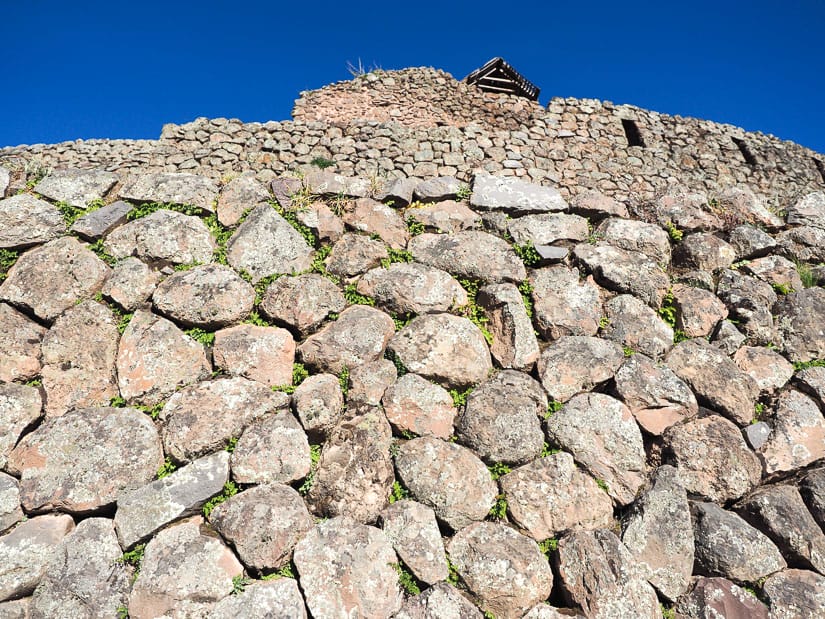
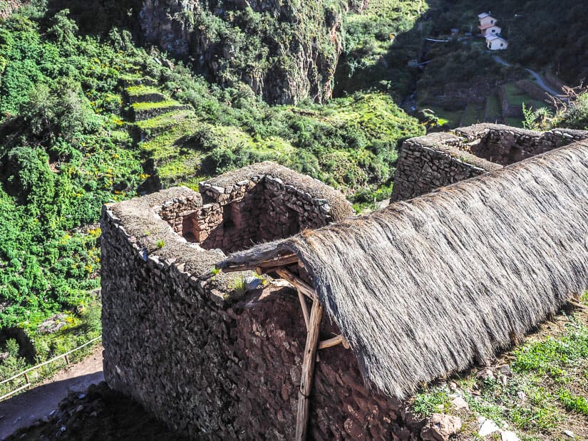
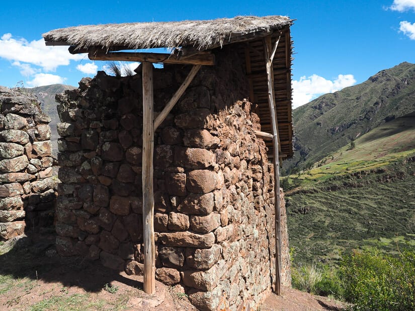
Once you get to the highest point of the Military Zone, you’ll find yourself on a circular lookout platform with 10 niches on its inner walls.
Look at the ground to notice the natural stone (see image below) – this is the actual peak of the mountain! This is the highest major ruins at Pisac, at 3514 m (11,529 ft), but we’ll later reach a viewpoint that is even higher.
From here, spend as much time as you’d like exploring the military zone. The thatch-roof building just next to the lookout platform is especially interesting, with another huge in-situ stone inside it.
You could easily spend anywhere from 5 to 30 minutes exploring this area, depending on how curious or eager to move on you are. You can also take a peek at the river valley at the back, where the cemetery was found, if you didn’t see it yet.
If you’re doing the short visit of the ruins, this is probably as far as you’ll go. Make your way back to the base of the Military Zone (there are several different paths going down) and then follow the Upper Path along the main terraces back to the entrance and parking lot.
If you’re walking back to Pisac, continue to the next section.
Closed Section and New Path to Intihuatana
For those who are walking all the way back to Pisac, or for anyone wanting to see Intihuatana and the Lower Ruins of Pisac before you finish your visit, the following instructions are especially important.
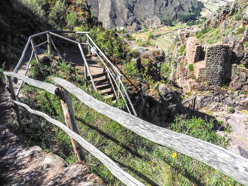
In the past, the main visiting path went through Amaru Punku (Sun Gate) at the base of the Miltary Zone, then continued straight along the slope of mountain (see photo above). The path then went through a cool tunnel before reaching Intihuatana and the other “Lower Ruins”.
This path is no longer open and it is roped off just a few minutes after the Sun Gate. Part of this path was destroyed in a landslide several years ago. This brought me so much confusion, because several blogs and maps of the Pisac ruins still indicate that this is the way you should go. This is actually the main reason I decided to write this article, so that I can inform visitors that you can’t go this way anymore!
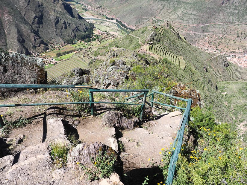
Instead, the new path you must follow goes OVER the mountain. The best way to find it is from the highest point of the Military Zone (see two photos above). From this lookout platform, take the stairs down the back of the platform. Looking to the left, you’ll see a path and sign pointing to “Intihuatana”. That’s the direction you’ll need to take!
This is why I recommend visiting the Sun Gate first. If you take the counter-clockwise route to visit the Military Zone, you’ll either miss the Sun Gate, or you’ll have to hike steeply downhill to see it, then steeply back uphill to continue on towards Intihuatana. And yes, this is exactly why I did – so that I can now tell you NOT to!
Mirador, Tunnel, and Llaqta Quarina
Once you’ve found the way, with signs pointing you toward Intihuatana, you can’t really get lost. New signs will start pointing you to “Mirador” (Viewpoint), although the views looking down on Pisac town are already amazing before you get to the viewpoint.
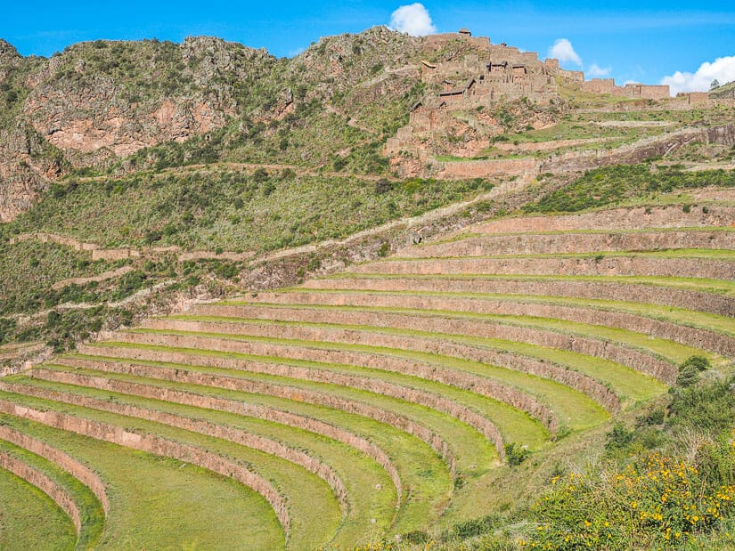
The Mirador offers an especially impressive, 360-degree view, including your first view looking down on Intihuatana (center of below photo). You’ll also get a birds-eye-view of Pisaqa Old Town (left side of below photo).
This is the highest point you’ll reach during your entire Pisac ruins visit (3525 m / 11,565 ft).
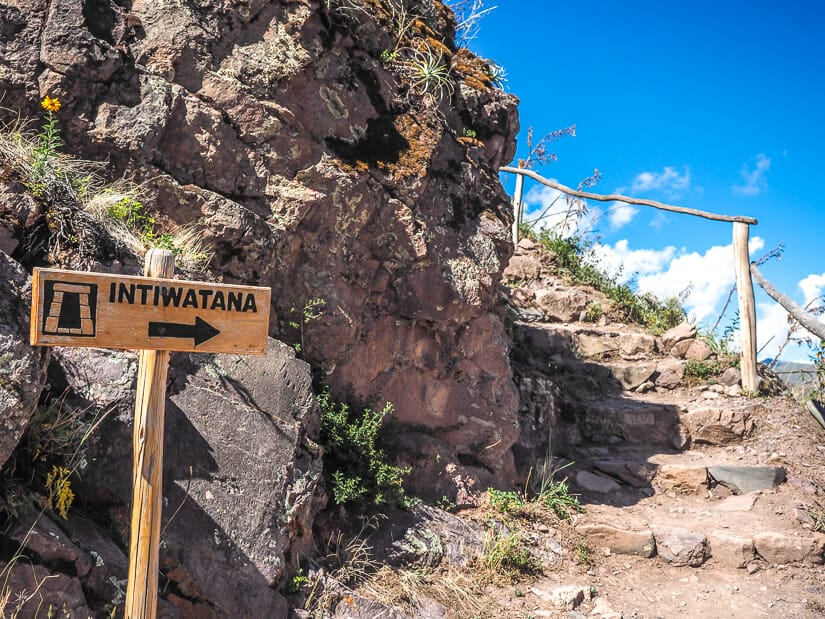
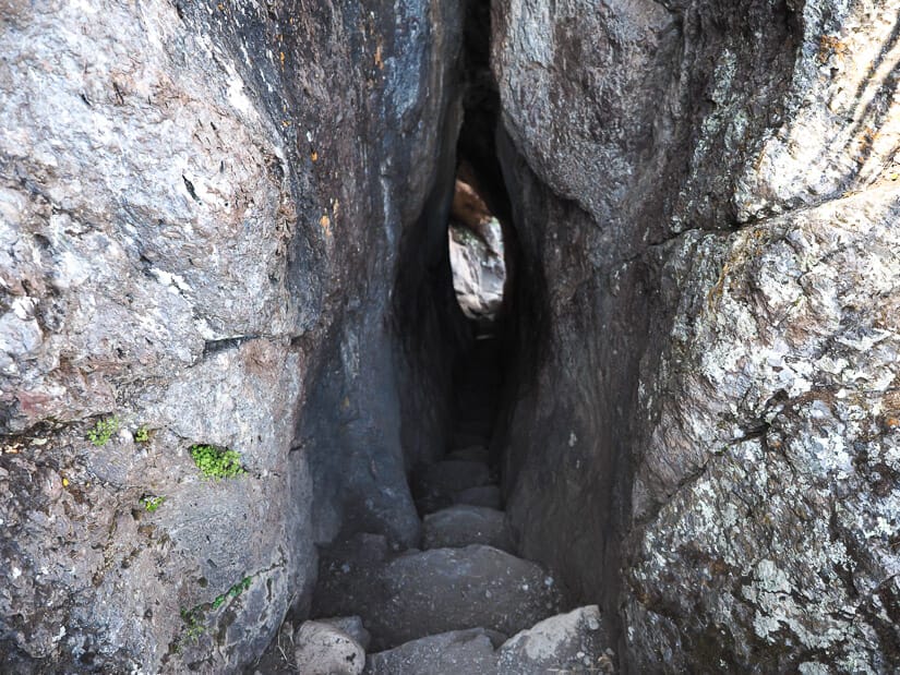
Next, the trail descends steeply down a set of wooden stairs towards Intihuatana. Before you get there, you’ll pass through a VERY narrow tunnel and a small ancient structure called Llaqta Quarina.
Ñusta Tiana/Tianayoc and Intihuatana
Next up, you’ll reach a sign pointing to “Ñusta Tiana”. Just after the sign, you’ll see these ruins on the right, with a path leading up into them (see photo above). Take this path! Ñusta Tiana, also called Qonqorina area, is though to be an Inca administrative area. It is the location of Tianayoc, a two-person seat carved out of a single stone.
The best part of Ñusta Tiana, though, is that the platform at the end of it offers the best view looking down on Intihuatana are and Pisaqa Old Town. Around here is also where the original (now closed) path from the Military Zone would have rejoined the path you are currently on.
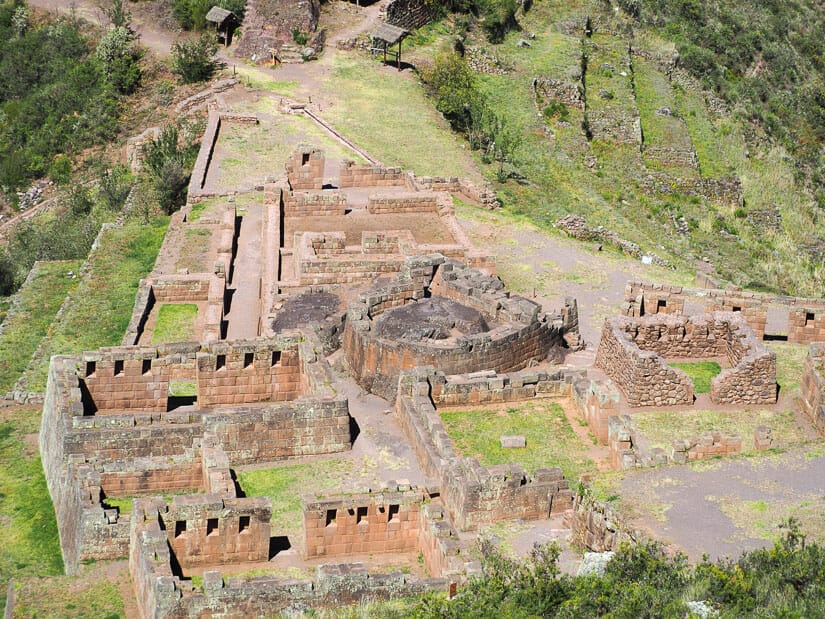
Continuing downhill, you’ll finally reach Intihuatana, which is the most sacred site at the Pisac ruins. An Intihuatana (or Intiwatana) is a carved stone often described as a kind of sun dial that lines up with the equinoxes. The Inca likely used them to track the sun’s movements and arrival of harvest seasons.
Today the Intihuatana at Machu Picchu is the most famous one, but the one at Pisac was actually well known before Machu Picchu was rediscovered. The word Intihuatana is derived from the Quechua language and meals “tied to the sun”, but it was likely invented by Hiram Bingham, the scientific discovered of Machu Picchu. They used to be many more but the Spanish destroyed most of them.
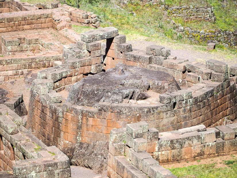
As you arrive at the Intihuatana area, first take a right to the small grassy platform beside it. It is best to view these ruins from slightly above, because you can’t see the Intihuatana stone very well from right beside it. This is where I shot the above photo from.
The Intihuatana stone, which is part of the natural bedrock, is enclosed in round walls – often the case with sun temples, included the Coricancha in Cusco and Torreon at Machu Picchu.
There are ruins of five other buildings around it, as well as a solitary stone doorway beside it.
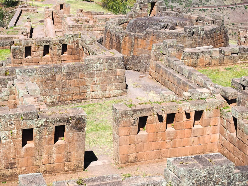
Next, as you walk through the ruins, note the extremely fine stonework, the best you’ll see anywhere at the Pisac Archaeological Park.
You aren’t allowed to climb any of the walls for trying to get a closer look at Intihuatana, and there is a guard station on site. However, I was able to get the below picture by lifting my camera has high as I could into the air while standing right beside it.
At the bottom of the site, note the running water canals. As you exit the double jamb doorway in the direction of the guard station, you’ll note that the water from these canals re-emerges just outside the entrance before disappearing again underground.
Pisaqa (Lower Pisac Ruins) and Hospitainiyoc
After you walk through the stone doorway at the bottom of the Intihuatana complex, you’ll have a few options.
The first is a path that veers to the left and steeply downhill to Pisaqa, also called Pisac Old Town or Hurin (Lower) Pisac ruins. This is yet another residential area of about 30 homes. I personally didn’t bother hiking down to these ruins.
Honestly, I was getting hot and tired by this point. But also, I felt that the view looking down on these ruins from Ñusta Tiana (see photo above) and from Intihuatana area was actually better than how the ruins would look up close. But for serious ruins geeks, you may want to go down! Supposedly the homes also have exceptional stonework, which likely indicates they belonged to the elite. From down there, the path will come back again and rejoin the one you’re on, but further down.
If you don’t go down, continue forward, with the sign stating “Camino a Pisac” (path to Pisac). You’ll soon reach an option to go left (no sign) or right (sign says “Casa Dos Pisos”). Either is fine, but I suggest to take the right to visit the Two Tier House (Casa Dos Pisos), a two-level storehouse. The paths will meet up again after that.
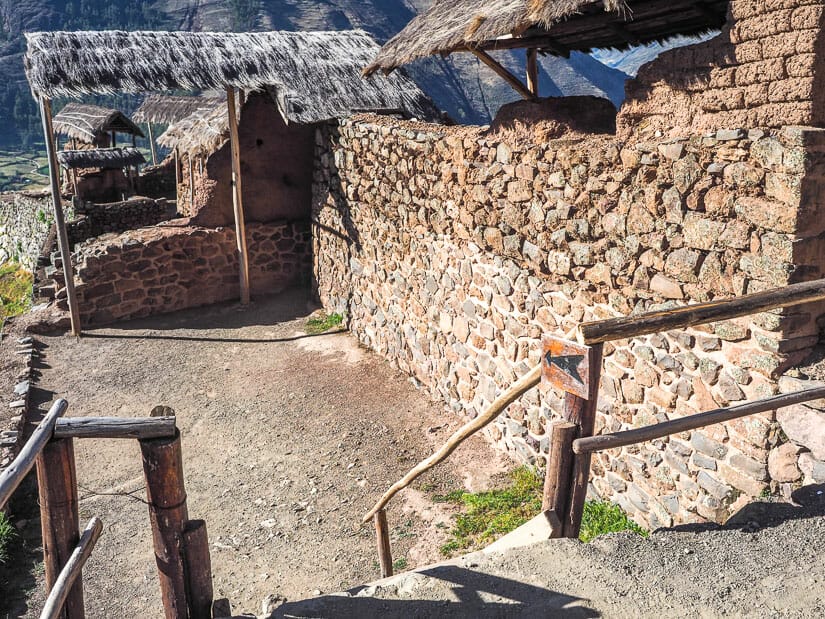
After that, you’ll soon come upon Hospitainiyoc. This is a collection of six storehouses or colcas. The path passes a ways to the right of these ruins – you can’t actually enter them.
The view of them is extremely impressive, with the Urubamba river visible far below in the background (see image below).
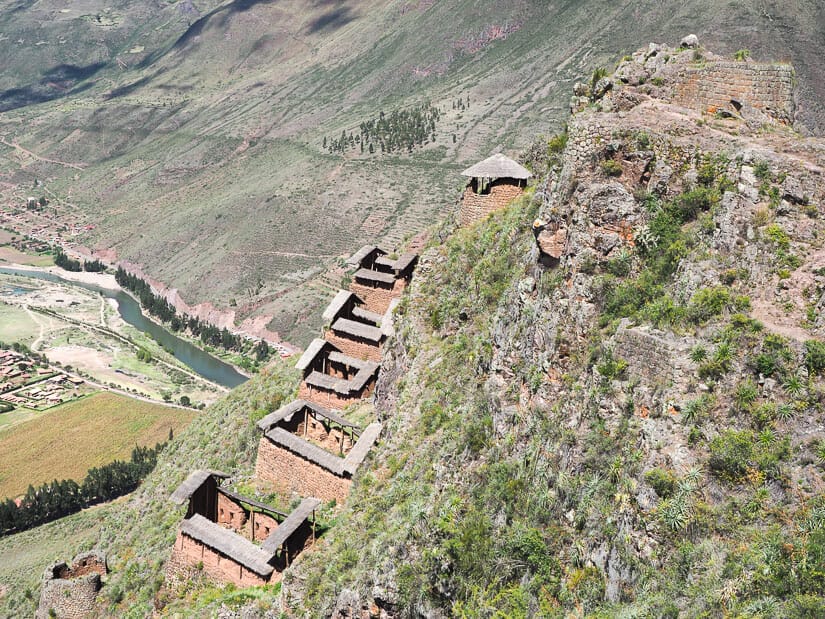
After that, you’ll pass right through a series of watchtowers with impressive views looking down on Pisac town. This whole area is called Sector Q’ente Muyurina and is the last major ruins of your Pisac tour.
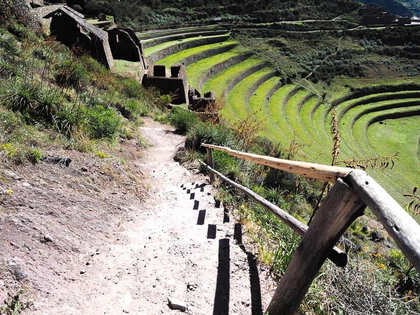
Terraces and Final Stretch to Pisac Town
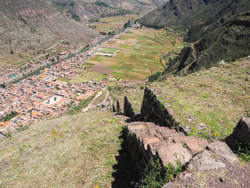
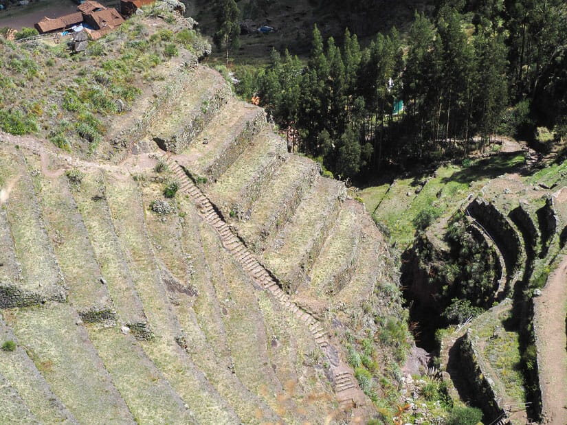
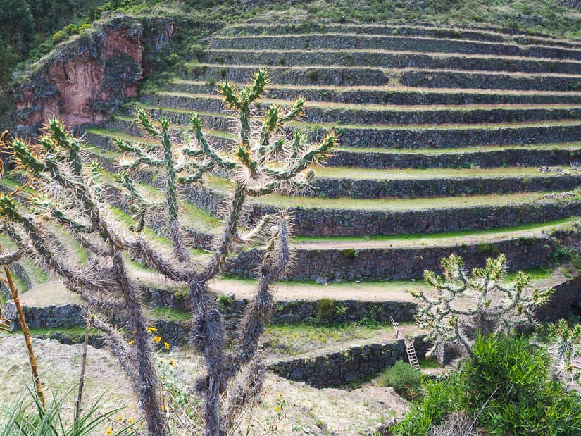
For the next 45 minutes or so, you’ll be walking steeply downhill to Pisac, mostly through the beautiful sets of terraces that you can see from town. This area is sometimes called Sector Wanuwanu.
Watch for a cave on the right side as you begin descending. The path eventually goes down into a little valley between two terraced hills (see image below), crosses a small wooden bridge over a creek (see next image after that), then continues along through even more terraces.
(Speaking of bridges in scenic locations, don’t miss my guide to the impressive Inca Bridge at Machu Picchu!)
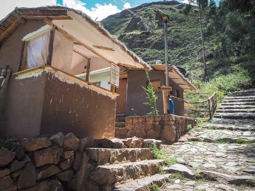
Finally, you’ll exit the terraces and reach the lower ticket booth called Acchapata (if you entered without a ticket, don’t worry, they won’t check you on the way out). Follow the stone path downhill past it, stopping at the restroom if needed.
Note the eucalyptus forest to your left as you descend to the paved street leading to the Pisac main plaza.
Once you reach the official entrance sign and paved road, a few more blocks will bring you down to the main plaza. If you started your visit early like I did (around 7:30 AM), you’ll reach the plaza just in time for lunch! Here are my recommended restaurants in Pisac for lunch.
Do You Need a Guide for Pisac Ruins?
I feel there are two types of traveler: ones who like using guides, and ones who don’t. I’m personally not a fan for several reasons:
When visiting ruins, I like going at my own pace, lingering or skipping things whenever I want to. A lot of the information shared by guides can easily be looked up on your own before or even while visiting the ruins. I always research and map out such sites before visiting (writing guides like this is literally my job, after all!) Finally, like many Inca ruins, there are a lot of things that are simply unknown about Pisac.
Overhearing some guides’ talks, I feel that they often fill in these gaps with information that is necessarily factual. This is particularly known to be a problem at Machu Picchu, and some “guides” have even been overheard bragging about how they just make up things for tourists.
Having said that, if you don’t want to do the homework, don’t want to get lost while visiting, or simply prefer to have a local show you around, then go for it!
If you want to save the money and do it your own way, I’ve tried to make this self-guided tour as complete and detailed as possible, so it should be all you need!
It was my goal to make this Pisac ruins guide as detailed and clear as possible. I hope that you can avoid backtracking or getting lost like I did with this updated information. If there were any gaps in this article, confusing points, or changes since I published it, please comment below so that I can update it. Also don’t miss these other fun things to do in Pisac!
Bonjour, merci beaucoup pour tous ces précieux détails pour préparer la visite de Pisac !
Hey Nick, just in case you think you’re posting into a void, we wanted to tell you that we found your post on visiting Pisac to be enormously helpful. We didn’t go into every nook and cranny you suggested (we thought the view of the storehouses was great without going around behind) but we followed your path pretty closely. Both the directions and the information were terrific and really enhanced our visit. Thanks a lot for posting that!
Thank you so much. I’m really glad to hear that!