Dear reader: This article contains links to products and services that I may be compensated for, at no extra cost to you.
People often associate Cusco, the ancient Inca capital, with Machu Picchu, the most famous Inca site. Many visitors fly into Cusco, rush to see Machu Picchu, and then fly out.
But did you know that the Cusco region has nearly 100 other major archaeological sites, and countless other smaller ones? In this article, I’m going to introduce just a quarter of these Cusco archaeological sites. These Cusco ruins are either the most famous ones, or lesser known ones that the average visitor can visit relatively easily. Most of them are Inca ruins, but a few are from other civilizations.
I have personally visited 26 out of the 30 ruins near Cusco that I’ll cover in this article – for those four I never made it to, I’ll mention this and include stock photos, but they are very important so they couldn’t be left out!
To make things easy, I’ve separated the ruins into sections on Cusco city center, east of Cusco, north of Cusco, Sacred Valley, Inca Trail, and finally west of Cusco.
Also don’t miss my guide to eating in Cusco and other places to visit in Cusco!
Table of Contents
Inca Ruins in Cusco City Center
You don’t even have to leave the Cusco city center to see Inca ruins. Here are a couple right in the city. You’ll find several more just outside of the city, too. For that, see the East and North of Cusco sections below.
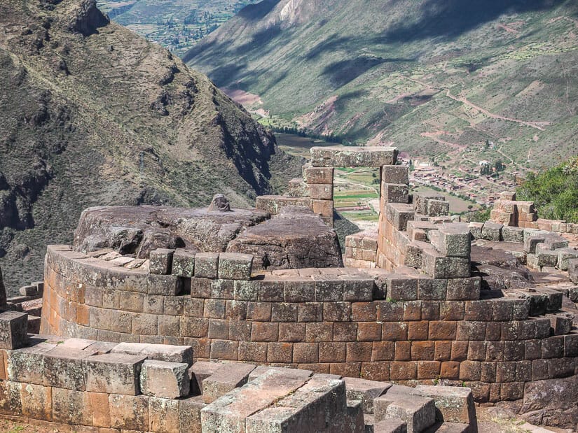
Coricancha
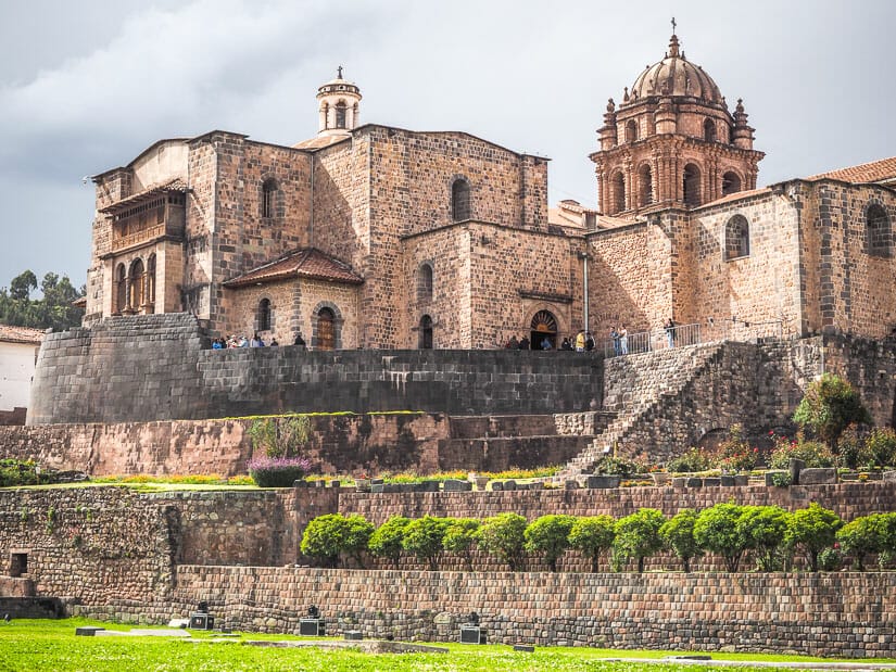
Coricancha (also spelled Koricancha or Qorikancha) was the most sacred and important temple in the entire Inca empire. Also called the Sun Temple, its name literally means “Golden Temple”.
This round temple was once covered in gold. It housed a huge sun disk that would reflect light, mummies adorned in accessories, and large golden statues of corn and other plants. It is thought that the Torreon (Sun Temple) at Machu Picchu, also round, is modeled on the Coricancha.
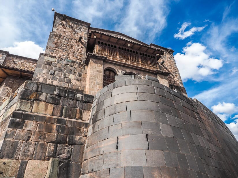
The Spanish razed most of the temple in the 16th century and built the Santo Domingo Convent atop the Inca foundation. They did it a second time after the original one was destroyed in the 1650 earthquake.
For visitors today, this is a 2 in 1 experience. From the outside, you can still see the original round Inca base, with the Spanish convent on top. It is best viewed from across the large Sacred Garden (Viracocha).
Inside, you’ll find a large courtyard, again with Inca foundations and Spanish top, including several beautiful paintings. The remains of four small Inca temples surround the courtyard: temples to the sun, moon, stars, and rainbow.
During your visit, you can also ascend to the second floor, look down on the convent’s church, and climb up to the bell tower for an impressive view of the city.
Entrance to the complex is 15 soles, plus 5 soles for the Bell Tower.
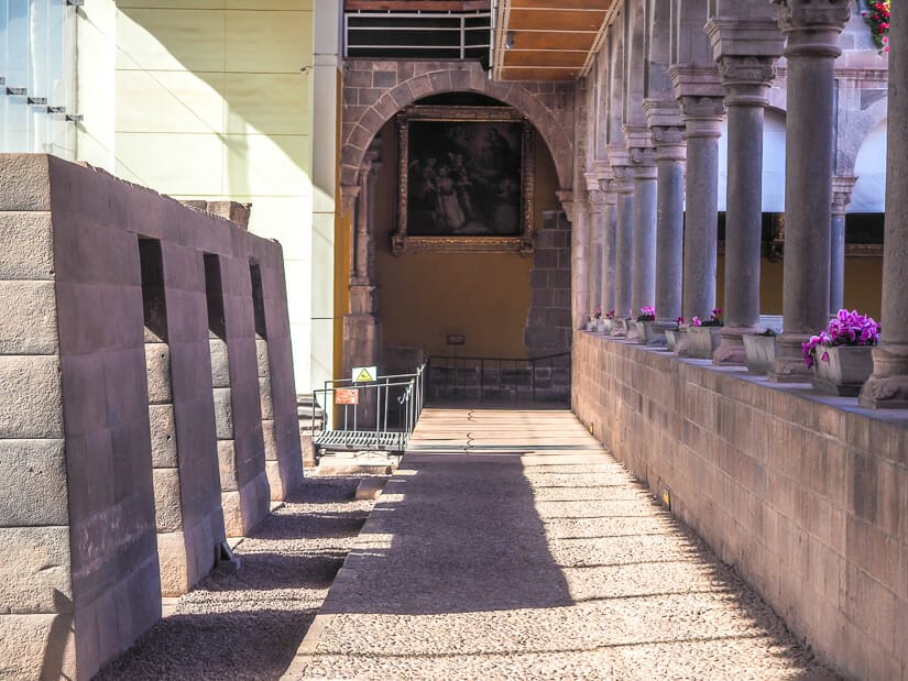
Kusicancha
There is a smaller and much lesser-known archaeological site close to Coricancha called Kusicancha, which means “happy enclosure”.
This archaeological site encompasses the remains of an Inca palace. It is believed that Pachacuti, the Inca who built Machu Picchu, was born and raised in this palace!
The Kusicancha ruins are today surrounded by glass and stone walls. There’s a good chance you’ll walk right past them on your way from the Plaza de Armas (the main square in Cusco’s historic district) to Coricancha.
The sign on the main entrance door (north side) says that the Ministry of Culture is housed inside and sells Machu Picchu tickets, but the door was always locked when I tried, so I never managed to enter these ruins. Some reviewers mention that after spotting a guard inside and knocking, they were allowed in.
The beautiful stone path to the east of the archaeological site (Romeritos road), which becomes Ahuacpinta road as is passes beside Coricancha, is an original Inca trail. It is part of the original Qapaq Nam, or Inca road system connecting the empire. One such road headed in each of the four directions from the main square, and this was the southern one.
Stopping in Lima on your way out of Peru? See my recommended Lima 2-day itinerary!
Ruins East of Cusco
There are three notable ruins around Cusco that are lying east of Cusco city center. They are in the Valle de Sur, formed by the Urubamba River before it reaches the Sacred Valley.
The first two ruins below are included on the Cusco Boleto Turistico (tourist pass) that you will likely be buying. They are perhaps the least visited (but in my opinion most rewarding) ruins included on the pass. However, getting to them is not so easy.
To reach the below three ruins, you can try this half-day tour. Personally, I engaged a private driver for half a day (US$ 60 through Taxidatum). I also included a stop at San Pedro Apóstol de Andahuaylillas, a chuch that is considered the “Sistine Chapel of the Americas” for its beautiful paintings.
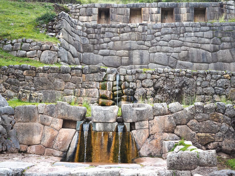
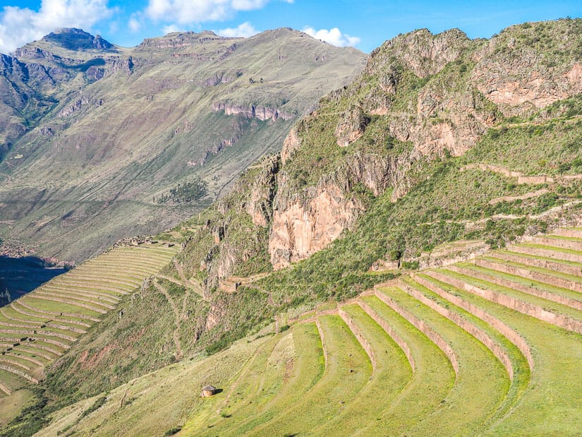
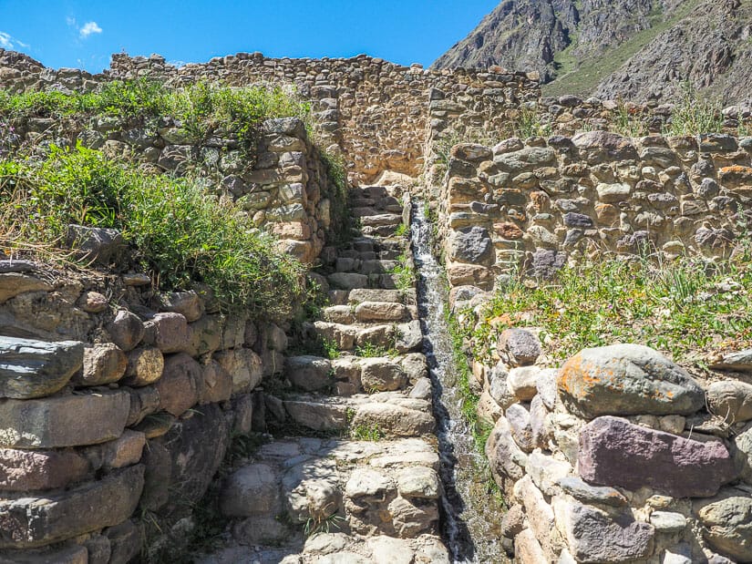
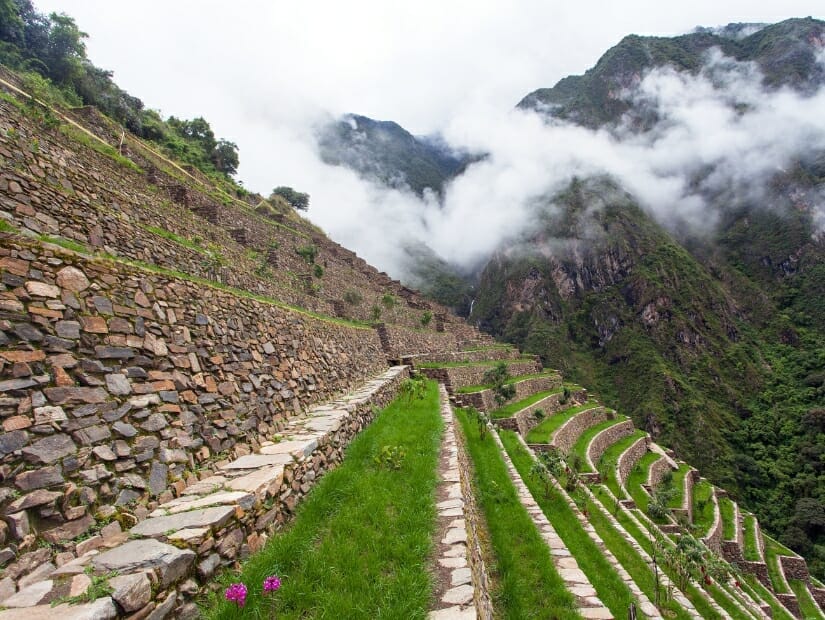
Tipón
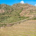
Tipón is the first major ruins that you encounter if driving east from Cusco city center. It takes about 45 minutes to get there, including a steep drive up a winding road at the end.
This archaeological site was likely the estate of Pachacuti or his son Yupanqui. The site features some very large terraces with some ruins around them. The highlight of visiting this site is to admire the ingenious irrigation systems between the terraces. These include some really beautiful canals and fountains, some of which you can walk right up to and feel the water flowing through.
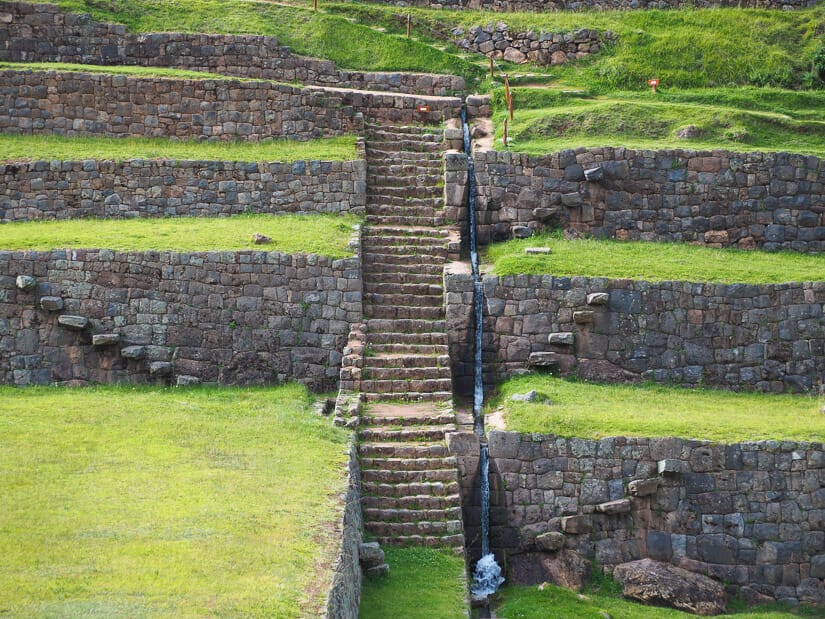
Tipón ended up being one of my favorite archaeological sites in the entire Cusco region, in part because I had the entire site to myself the whole time I was there. If you want to have the same experience, I recommend going early – I left Cusco at 7 AM.
My experience at Tipón was incredibly soothing, especially thanks to the sound of flowing water. My visit took 45 minutes, which included the main loop to the top of the terraces, including a short detour to see the ruins of Sinkuna Kancha on the side.
There’s another side trail called Camino Prehispanica, leading to a smaller area of the ruins called Intihuatana, which would take a little more time.
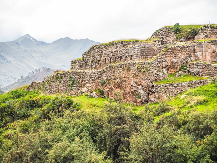
Pikillacta
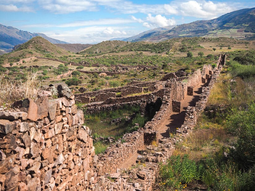
Only 20 minutes’ drive past Tipón lies another incredible archaeological site, also included on your Cusco Tourist Pass. This is one of the few non-Inca archaeological sites in this article.
Pikillacta is a sprawling city and ceremonial site built by the Wari civilization. They inhabited it from around 550 to 1100 AD. The site is so large that you’ll drive right into it, showing your pass at the checkpoint on the way in.
The most impressive parts of Pikillacta for me were the sheer size, the unbelievably long walls and corridors, the lack of tourists, and the feeling that this is still very much an active archaeological site.
The city is rectangle-shaped. You can walk along the entire wall around it, which is as high as seven meters in some parts. Your driver will likely drop you at the middle of the bottom wall, from where you can follow the trail into the middle of the rectangle. There you can see some active archaeological sites. Many of the houses you see were once two stories tall, with ladders used to access the second floor.
From the ruins in the center of the rectangle, I suggest then walking up to the back wall and ascending it. Then you can walk along the wall in either a clockwise or counter-clockwise direction all the way back to the entrance where you were dropped off.
I suggest choosing a direction based on which one will give you better sunlight looking down on the ruins (for my morning visit, it made sense to go clockwise). This means I only walked half of the total wall around the rectangle, but that was enough for me.
From some points in the ruins, you can see the Laguna de Huacarpay, which is just across the highway from the ruins. Beware of bees/hornets, which seem to live in many of the walls at these ruins. My visit took around 30 minutes in total but would have been longer if I would have walked both halves of the outer wall.
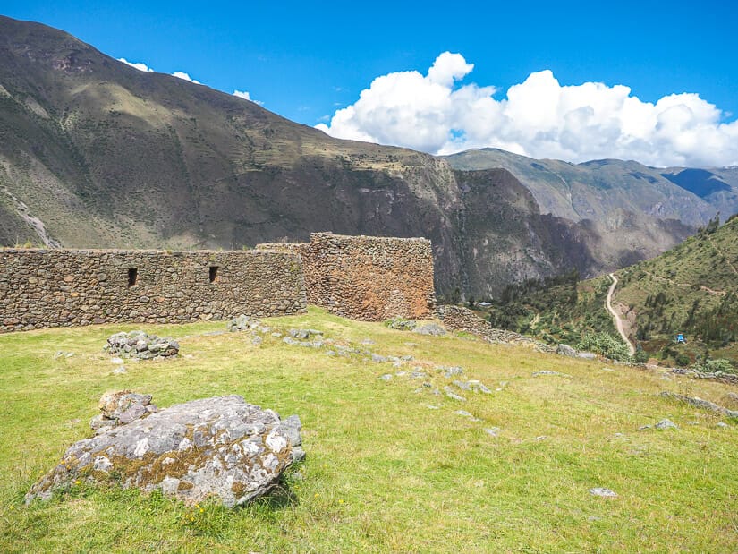
Rumicolca
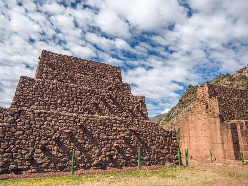
If you make it as far as Pikillacta, then it only makes sense to also visit Rumicolca. These ruins are less than five minutes’ drive from the latter and are totally free to visit.
Rumicolca means “stone storehouse”, but there are several different theories as to what this large wall/gate-like structure really was. The most common is that the Wari people first built it as a kind of aqueduct, but the Inca built upon it and used it as a kind of entrance gate or checkpoint for visitors coming to Cusco.
It only takes a few minutes to visit Rumicolca, including walking through the two main openings in the wall and admiring it from either side.
Ruins North of Cusco
There are a large number of ruins dotting the vast plateau north of Cusco. These include four very famous ones that many tourists visit and which are included on the Boleto Turistico (Sacsaywaman, Q’enqo, Puka Pukara, and Tambomachay). These four can easily be visited on a day tour like this one.
But they also include some smaller and far less visited ones. I’ve only included a few of those here, the ones that I personally visited, but eager explorers can find even more nearby (I’ll mention the names of more of them in the “Templo de la Luna” section below).
If you’re visiting on your own, figuring how to pack all these ruins into one visit can be a challenge. Here’s what I did. I first walked from Cusco uphill to Sacsayhuaman early in the morning (around 7 AM) to enjoy these famous ruins before all the tourists arrived. Staying in San Blas will make this an easier walk that coming from the square. I stayed at Samay Wasi Hostel (private rooms available, see on Booking / Agoda / TripAdvisor / HostelWorld) with an incredible view.
After Sacsay, I walked to the main road and caught a colectivo to Tambomachay (you could also take a taxi, but the driver will try hard to sell you a full day tour). From Tambomachay, I walked all the way back to Cusco, stopping at Puka Pukara, Manos de la Communidad (do see llamas, not ruins) Zona X, Temple de la Luna, Christo Blanco, Q’enko and San Christobal church on the way down. I was back to my hotel in San Blas around 2 PM.
The last three ruins in this section (Chinchero, Moray, and Huchuy Qosco) are further away and will require a longer drive from Cusco. Chinchero, Moray, Pisac, and Ollantaytambo can be visited on Sacred Valley tour like this one.
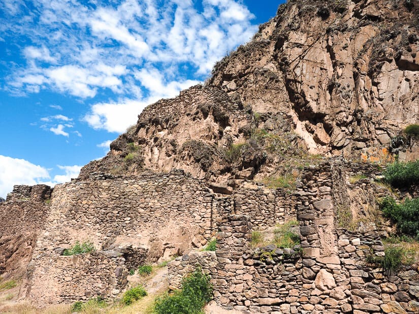
Saqsaywamán

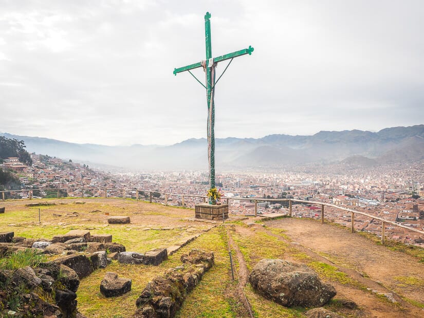
Saqsaywamán ruins (also spelled Sacsaywaman or Saqsaywan, and famously pronounced like “Sexy Woman”) are right on the edge of Cusco city and are the most famous Inca ruins near Cusco.
This large archaeological site sits right on the ridge of the city above San Cristobal neighborhood, directly north and uphill from the main plaza of Cusco. Although you can’t see most of the ruins from the city, you can see a large cross marking the spot where the ruins begin.
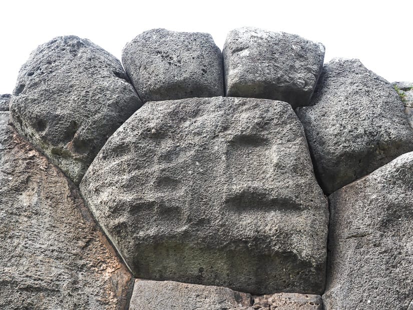
Saqsay was an immense fortress protecting the city. It is especially known for its zigzag rows of stone walls, which you can walk between.
The most impactful aspect of visiting, for me at least, was to take in the sheer size of the massive stones used in the walls – the largest single stone is over 8 m (28 ft) tall and weighs 300 tons! It’s hard to even imagine how the Inca moved and placed such enormous stones.
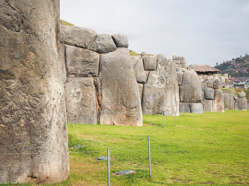
If you visit with a guide, they’ll point out the many patterns/designs formed by stones in the walls, with the most famous being the puma paw. Visiting on my own, it took me a while to find it – it’s on the lowest zigzag wall facing the large grassy field, about 4 zigzags in from the western end.
You’ll notice the trodden path on the grass kind of ends at it. Also don’t miss the Inti Punku (Sun gate) at the other end of the zigzags – you have to look back to see it, so I almost missed it the first time!
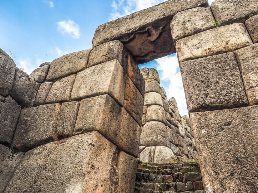
A typical visit takes a few hours. Besides the zigzag wall, there’s also a loop trail out to the to cross looking over Cusco, which has some small ruins too. There are several other areas of ruins, including a Grand Staircase, rock slide at Suchana Hill, and cool stone tunnels at Chinkana Chika in the northernmost section.
Many tours stop in at Sacsay. You can also walk there from the plaza. It’s about 15 minutes uphill through the city from main plaza to the control booth, where you might have to show your ticket. It is then another 15 minutes steeply uphill on the path to the start of the ruins. You can also just hop in a taxi from Cusco (10 minutes, 10-15 soles).
Q’enqo
Q’enqo is another set of ruins on the northern ridge of the Cusco valley, just 1 km east of Sacsaywaman, as the crow flies.
Q’enqo is not as large or famous as Sacsaywaman. Nevertheless, it is still worth visiting and is included on your Boleto Turistico.
Q’enqo was an important huaca (holy site) mostly carved into the naturally occurring stone on site. Experts believe that sacrifices were done here, at the top of the site, with little canals for the blood to pour down through the site.
The first thing you’ll notice when you enter the site is the huge monolithic stone standing upright. You can then walk around or right through the middle of the ruins. At the center, you’ll pass through a tunnel and cavernous room with seats or altars carved into the in-situ stone.
There’s also a lower area of ruins which you can walk down to, with a lovely eucalyptus forest beside them. In total, 15-30 minutes is enough for this site.
It is possible to walk from Sacsayhuaman to Q’enqo via Christo Blanco, the large white Jesus statue overlooking Cusco. There’s a walking path from Sacasay to the Jesus, and then you’ll be walking along a road from the Jesus to Q’enqo.
Templo de la Luna
Templo de la Luna (Temple of the Moon) is a much smaller and rarely visited set of ruins surrounded by farmland northeast of Q’enqo.
Here, a temple dedicated to the moon and Pachamama (the earth goddess) was carved into a stony hill jutting out from the plain. The main set of ruins here are now roped off (you used to be able to explore them more closely) but still easily admired.
I suggest doing a full circle around the hill, as there are other carved niches and stones. It’s also possible to climb the hill and find more on top. Unsurprisingly, as these ruins are rather remote, I didn’t see anyone else there, but passed some farmers and people riding horses in the way.
Besides the ruins themselves, my favorite part was getting to them. I walked to them from the main road around Zona X (see next entry). Although it looks like there’s a road from there to Templo de la Luna on GoogleMaps, this is actually just a horse trail through farmland.
It took me 20 minutes to walk from Zona X to Templo de la Luna (mostly flat). Then it took me around 15 minutes to walk from Templo de la Luna to Q’enqo (a little up and down) via farmland and a lovely eucalyptus forest.
It is possible to hike to several other ruins in this area that I haven’t included. These include Mesa Redonda, Qochapata, La Torta, Inkilltambo, Huaca Cheqtaqaqa, and Chuspiyoc. See here for a guide to hiking to all these remote (and free!) Cusco ruins in one day.
Zona X
When I was walking along the main highway from Puka Pukara and Tambomachay (see below) to the lower ruins of Templo de la Luna and Q’enko, I noticed this spot marked “Zona X” just off the highway on GoogleMaps. So I had to check it out!
This archaeological site is not so much ruined buildings as it is a collection of tunnels and carved surfaces. Some experts believe it could have been a quarry site. In total there are at least 15 tunnels here, most of which you can walk (or just barely squeeze!) through. A flashlight is essential for some of them as they are long and pitch black inside!
Zona X is worth visiting if you’re passing by and is very fun to explore. There’s an AllTrails map for the small loop trail around it, though you’ll probably go off the trail as you explore the tunnels.
The AllTrail entrance to the site is a little wrong. You can’t enter it off the main highway, as the map indicates, without climbing over a farmer’s barbed wire fence. Instead, turn down the road with a sign pointing to Sacsayhuaman, then you’ll see the correct entrance path the ruins on the right.
Puka Pukara
Puka Pukara, or the “Red Fort”, is a fortress lying on the main road between Cusco and Pisac. The name comes from the reddish color of the stone used there, especially in the early evening before sunset.
Not so much is known about Puka Pukara. It likely served a military purpose, such as an Inca checkpoint for visitors coming to Cusco, as it has a good view up the valley.
Because it is on the Boleto Turistico and is so close to Tambomachay (also on the Boleto), many tourists visit Puka Pukara. It’s not a huge site, so you’ll likely only spend about 15 minutes here, which will include walking to the top of the fortress (not very difficult or steep) to enjoy the view.
The best view and picture I got of this site (see above image) was actually from the main road/walking path between Puka Pukara and Tambomachay. It only takes 5-10 minutes to walk between the two sites.
Tambomachay
Tambomachay is the furthest you are likely to go on a tour of the ruins just north of Cusco city center. Depending on how you plan your day, you may go here first by tour, taxi, or colectivo, then work your way back to Cusco. Or you may go here last. For me, I saw Sacsaywaman first to beat the crowds there, then came here, then worked my way back dowj to Cusco.
Tambomachay is a comparatively small site whose main feature is a beautiful series of aqueducts, canals, and fountains flowing through a set of terraced walls. These likely served a ceremonial or purifying function. They are also called “The Baths of the Incas”.
It only takes about 20 minutes to walk in (slightly uphill), see the main set of fountains, and walk back down. You can also do a short or longer loop trail above these ruins, which gives you a view looking down on them.
Chinchero
Chinchero is a weaving village that is also famous for its ruins, which are included on the Boleto Turistico. It is located on a picturesque high plateau called the Anta Plain on the drive between Cusco and Urubamba (one-hour drive from Cusco) in the Sacred Valley.
At 3,762 m (12,343 ft), it is even higher than Cusco, so you won’t want to go here until you are acclimatized.
The ruins are Chinchero are thought to have been a retreat and spa of Tupac Yupanqui, the son of Pachacuti. The Inca’s called Chinchero the “Birthplace of the Rainbow”.
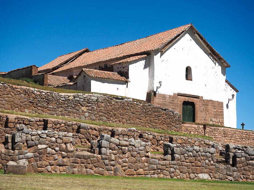
These ruins include some beautiful agricultural terraces. You’ll access them from a square that includes a Spanish church (Iglesia de Nuestra Señora de la Natividad) built atop the foundations of the original palace.
From the ruins, there’s a two-hour return hike to Catarata Poc Poc, a beautiful waterfall in an even more beautiful valley. The hike goes steely downhill, so it’s the return journey that’s a bit of a killer.
Many Sacred Valley tours from Cusco include a stop in Chinchero to see the ruins and watch a weaving demonstration in town. There’s also a traditional marked held near the ruins every Sunday.
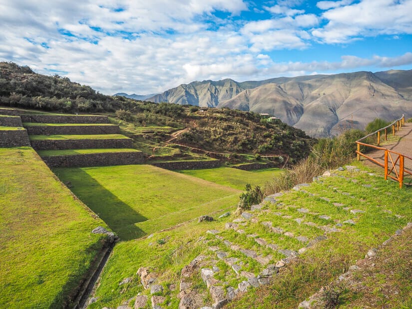
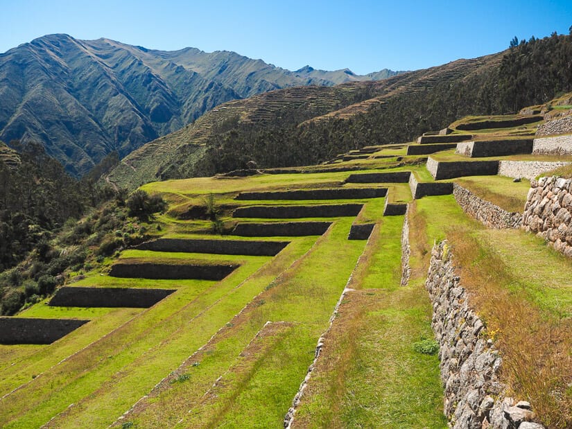
Moray
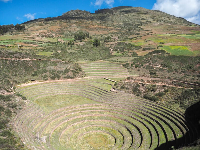
After Chinchero, most Sacred Valley tours naturally continue on to the impressive circular terraced ruins. They are just Moray just past the high mountain village of Maras. These ruins are also included on the Boleto Turistico.
Moray’s circular terraces, which form round depressions up to 30 meters deep, were used for agricultural experimentation by the Incas. There is a staggering temperature difference of up to 15 degrees from the highest terrace to the deepest one.
This allowed the Inca to test and grow various crops that otherwise wouldn’t be possible to grow at such altitudes. Thanks to irrigation canals and an underground aqueduct, the canals would never be flooded.
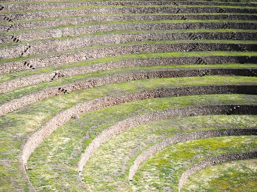
Arriving at Moray, you’ll immediately enjoy a great view of the main terraces. You have the option to take a lower or upper walking route around them. The lower one still offers great views.
Halfway along, you have the option to cut back across the middle, or continue along to go around another smaller terraced depression. As you make your way back up, there are various lookout platforms offering every angle possible of the ruins.
From the south end of the upper trail, you can see the peak Mt. Veronika, one of the most sacred mountains for the Inca, rising up in the distance.
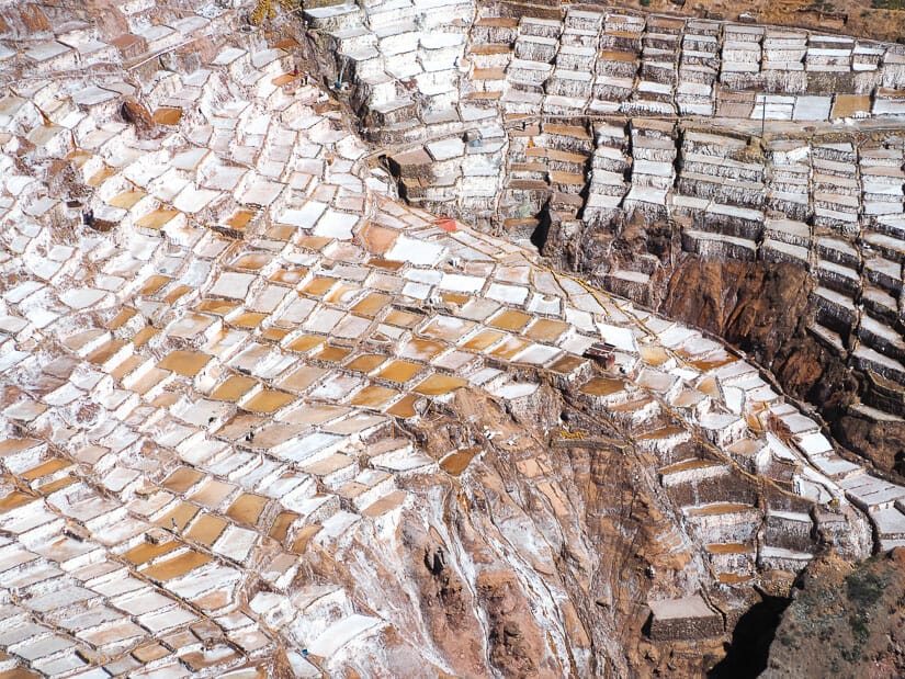
From here, almost all tours will also make a stop at Salineras, also called Maras Salt Mines, nearby. These are an incredibly impressive sight.
On your own, if you want to get from Chinchero to Moray, you’ll need to catch an Urubamba-bound colectivo, get off at Ramal, and hike in (about 2 hours) or try to find a taxi (not easy).
I highly recommend Mountain View Maras in this area. It features A-frame cabins with outstanding views, hot tubs, and an excellent bar and kitchen. From there, I was easily able to visit Moray and Salineras. This accommodation was one of the highlights of my Peru trip.
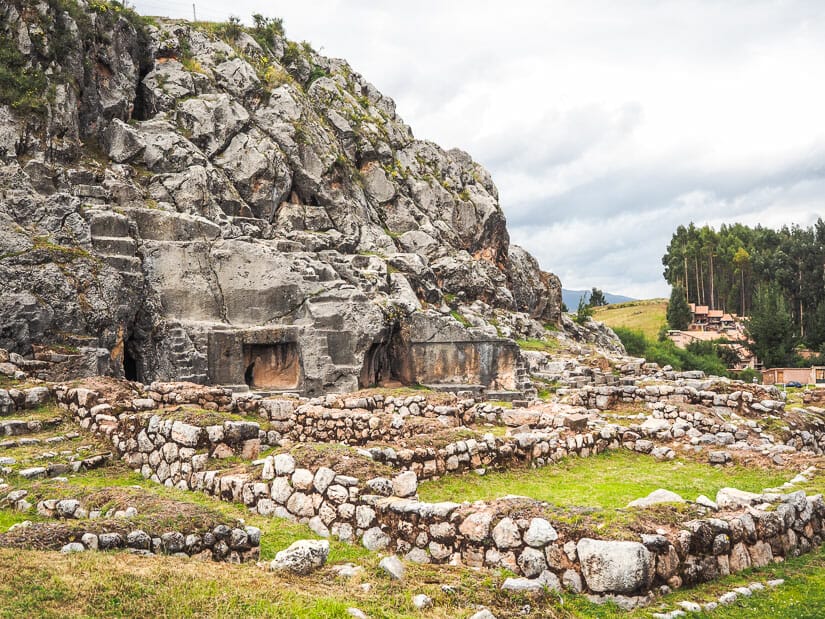
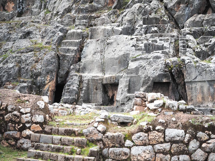
Huchuy Qosqo
Huchuy Qosqo (or Juchuy Coscco) is a significant but difficult-to-reach archaeological site in the mountains rising to the west of the Sacred Valley. They are the most important ruins in the region after Machu Picchu, Ollantaytambo, and Pisac, but they are by far the most difficult to reach.
The ruins were likely a royal estate of Viracocha, father of Pachacuti. They form an expansive high mountain site that includes a great hall, terraces, storehouses, and more. Because they are so inaccessible, there’s a good chance anyone who makes the journey will have them all to themselves.
The longer but easier options for hiking to Huchuy Cusco includes starting from Chinchero or Tambomachay, either one taking 6-7 hours just to get there. A shorter but more difficult way is a to start at the village of Lamay in the Sacred Valley, near the popular Parwa restaurant, then hike a series of very steep, uphill switchbacks to the ruins, taking 2-3 hours.
Sacred Valley Ruins
The Sacred Valley is a picturesque valley formed by the Urubamba River as it flows toward Machu Picchu.
While I personally recommend spending several days exploring the many things to do in the Sacred Valley, most people do a whirlwind day tour of the valley’s most famous ruins from Cusco, such as this one.
Two of the below are very famous ruins included on your Boleto Turistico (Pisac and Ollantaytambo), while the others are very much off-the-beaten-track.
I’ve listed the ruins roughly from east to west, or closest to Cusco to closest to Machu Picchu.
Pisac Ruins
Pisac is a town lying at the eastern end of the Sacred Valley, closest to Cusco but furthest from Machu Picchu. The ruins, called Pisac Archaeological Park, lie hidden on a mountaintop 400 meters above the town site. Read my detailed self-guided tour of Pisac ruins for all the details about visiting.
The ruins include over 500 agricultural terraces, ceremonial fountains, impressive lookouts, tunnels, watchtowers looking down the valley, and an Intihuatana (similar to the one at Machu Picchu). There’s an option for a shorter loop (1 hour), which most visitors do. But this loop misses some of the best spots. There’s also a longer one that involves hiking all the way back to town (3-4 hours, recommended if you can!)
I was particularly impressed by the ruins at Pisac, especially when I had the entire site to myself early in the morning.
Although the ruins at Ollantaytambo are more important historically, I found the overall setting at Pisac’s ruins more stunning. I’ve also got guides to the best restaurants in Pisac and other things to do in Pisa.
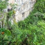
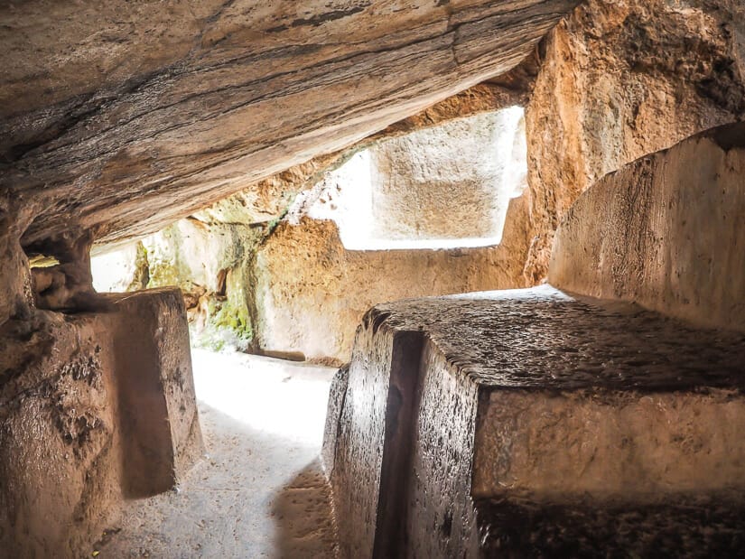
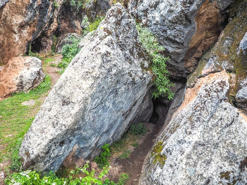
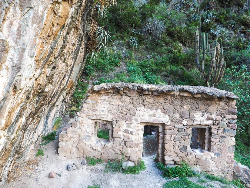
Ñaupa Iglesia
Ñaupa Iglesia (Choquequilla) ruins are shrouded in mystery. These are some small but magical ruins in a cave that is not super easy to get to, but rewarding for those who make the trip. Here’s a detailed guide to getting to Ñaupa Iglesia.
The name Ñaupa Iglesia itself is a combination of Quechua and Spanish words. At the cave’s entrance, there is an elaborately carved stone altar. A stone wall with niches juts out from the cave (see image above), while inside there is a perfect rectangular niche carved into the wall. More small ruins lie just outside (see image below).
While these ruins aren’t very big, there is a kind of energy or spiritual feeling in their location, not to mention the view from them. The cave is located just outside the Sacred Valley, on the road going up from Pachar, which is also the way that the Cusco-to-Machu Picchu train travels.
To get there, you can take a colectivo to Pachar or walk there from Ollantaytambo, which I highly recommend! The walk from Ollantaytambo along the south side of the Urubamba River is highly scenic and passes some other small ruins called Chocana. See my Ollantaytambo guide for all the details.
Also watch for Sky Lodge, those hanging hotel pods on the cliff on the opposite side of the river just before Pachar.
It is a 30-minute walk from Pachar to the site along the road or train tracks (better option), then a very steep 10-minute walk up to the cave – I even had to use my hands for a few parts of the climb. There’s a good chance you’ll have the cave to yourself, but by chance I found four people hanging out there when I visited.
On the way down, it only makes sense to go for a beer at Sacred Valley Brewery. This is their main location where the beer is actually brewed. Also don’t miss these other great restaurants in the Ollantaytambo area!
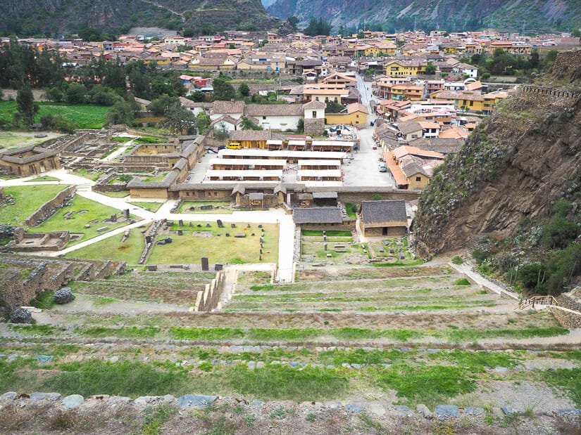
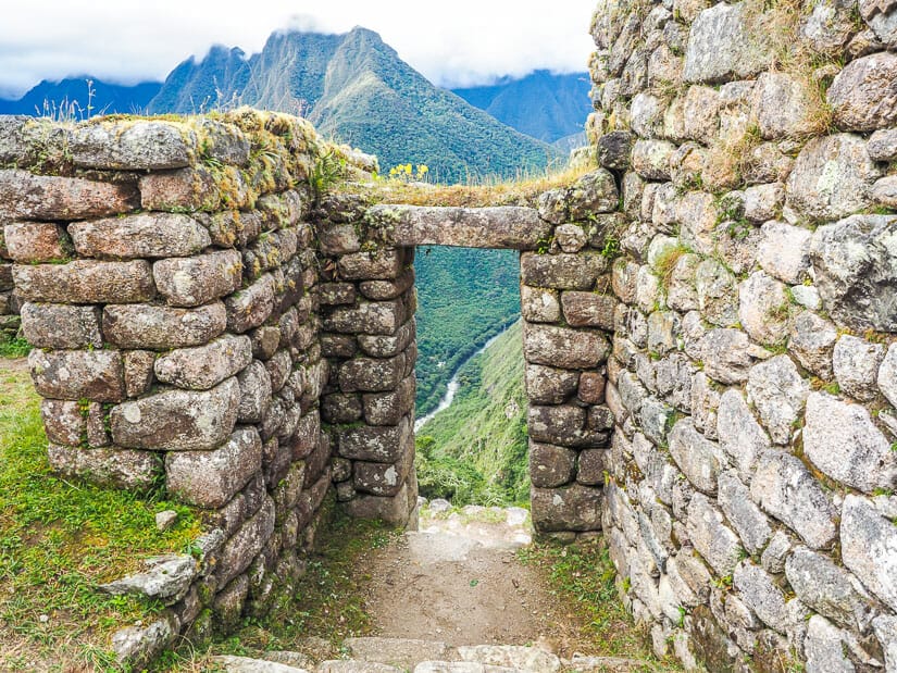
Ollantaytambo Ruins
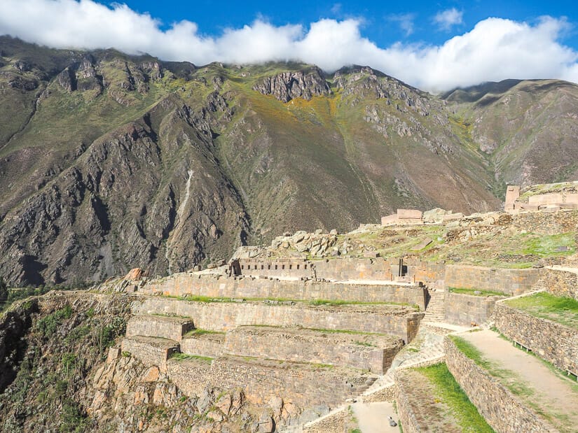
Ollantaytambo is the name of a Sacred Valley town and their main ruins, the Ollantaytambo Sanctuary or “Sitio Arqueológico De Ollantaytambo”. See here for my guide to visiting Ollantaytambo.
These are the most famous ruins in the Sacred Valley and second in importance only to Machu Picchu itself. Pachacuti built Ollantaytambo as a temple and fort to protect the Inca against attacks by the antis (jungle tribes) coming up the valley.
During the Spanish siege of Cusco, the Inca Manco retreated there. It is famously the site of the only Inca defeat of the Spanish. When Hernando Pizarro tried to lead a sneak attack in the early morning, Manco and his troops beat them by raining stones and arrows down on them and flooding the valley.
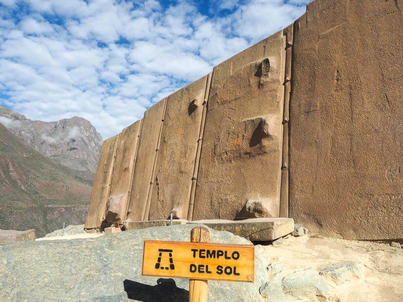
The ruins of Ollantaytambo lie right beside the town and are easily visible from it. Upon entering, you’ll ascend 200 stairs up 17 imposing stone terraces. Next you’ll walk past 10 niches and through the Sun Gate, the most photographed spot. At the top is the Sun Temple, composed of six enormous pink stone monoliths.
A side trail to Inka Watana was closed when I visited. From the top, a trail crosses the top of the terraces to some colcas (storehouses). You then descend through more terraces to a lovely section of ceremonial fountains, Princess’ Bath, and Water Temple.
A typical visit takes about a couple hours. Go when it first opens at 7 AM to have the ruins all to yourself. You can walk to the ruins from anywhere in town.
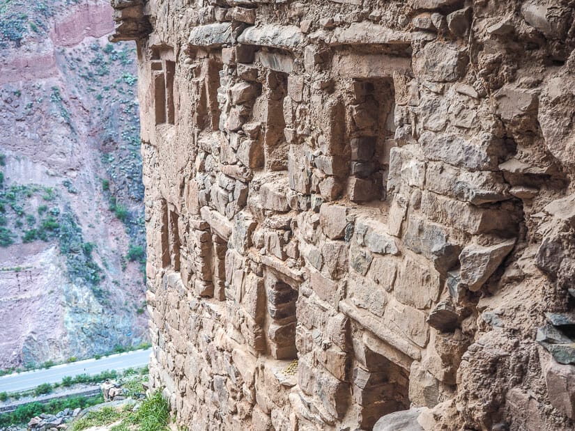
Pinkuylluna
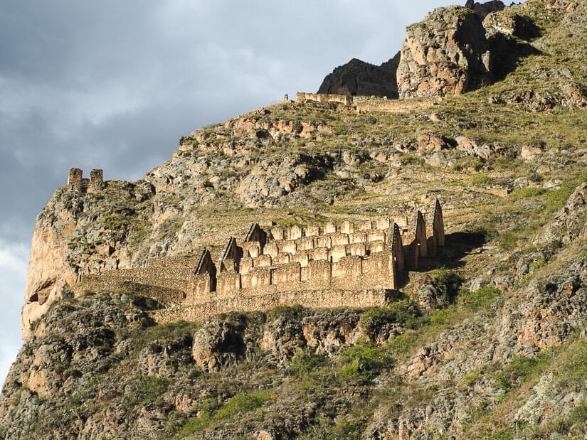
While the main ruins dominate the western end of Ollantaytambo town, another set of ruins hang from the slopes at the eastern end of town.
The Pinkuylluna Storehouses, or Depositos de Pinkuylluna, are a collection of Inca colcas or grain storehouses. These ones are particularly picturesque, especially when viewed from Ollantaytambo town in the late afternoon, when they are illuminated by the setting sun.
There is another small collection of ruins on the same mountain, also overlooking Ollantaytambo, and both are easily visible from town. Hiking up, it only makes sense to visit both as a loop. After a few minutes of climbing, go right to visit those other ruins first. Around the top of them, you’ll find an arrow sign and trail cutting across to Pinkuylluna.
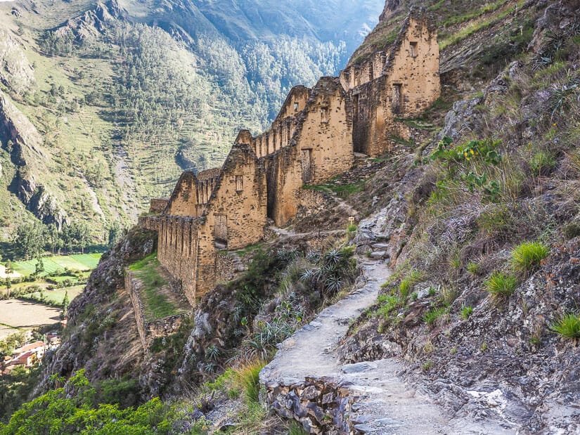
The views looking down on Ollantaytambo town and Ollantaytambo’s main ruins from either site are breathtaking. If you do this hike early in the morning like I did, you catch watch the ruins on the opposite side and then the town slowly light up as the sun rises over the mountain behind you.
It only takes about an hour to visit both, but it’s a steep uphill climb. The entrance gate to the hike is in the wonderful Qosqo Ayllu or original Inca neighborhood of the city. It is directly opposite Kamma Guesthouse (see on Booking / Agoda / TripAdvisor).
I absolutely adored staying at Kamma Guesthouse. The two local female owners were unbelievably helpful and friendly. I could hear the sound of water in the Inca canal on the street at night, and from the rooftop patio where they serve breakfast, I could see both the main Ollantaytambo ruins and Pinkuylluna.
Punku Punku & Inka Pintay
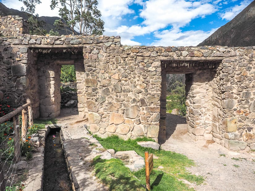
Punku Punku was the traditional entrance to Ollantaytambo for those arriving from the east. It is a double stone doorway at the eastern entrance to town, with the main road into town passing right by it.
You can walk from the main square in Ollantaytambo to Punku Punku in just five minutes. Note the “100 Niches” in the original Inca Wall along the way.
Reaching Punku Punku, I urge you to walk through it and continue walking another 10 minutes to Inka Pintay. This is a beautiful walk featuring rural scenery and views of the Urubamba River just before it reaches town.
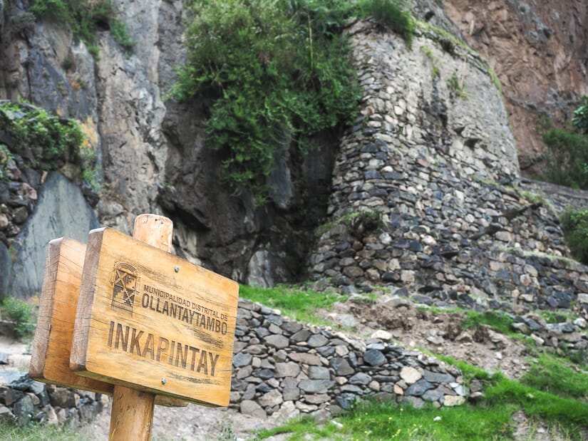
At Inka Pintay, there is a small collection of ruins just beside the road. These include a small tunnel, a niche in a wall, and looking up, a system of elevated irrigation canals. Depending on how adventurous you are, you can climb up to admire those up close.
Although I didn’t do it, there is a difficult, steep hike that starts around here up to some more colcas and a difficult-to-see portrait of Manco Inca painted on a cliff face. To find the trailhead you’ll have to climb to the terraces above the trail from Punku Punku to Inka Pintay.
Qelloraqay
At the south end of Ollantaytambo town, there are some lovely and totally free ruins to explore called Qelloraqay. This is another relaxing yet rewarding easy walk from Ollantaytambo that is the perfect escape from the touristy town center and all its hassle.
To reach these ruins, walk west from the main square in Ollantaytambo towards the bridge and main ruins. Before the bridge, hang a left on Av. Estudiante, passing the ATM. You’ll soon be walking a path along a small canal with flowing water. Continue until you reach a large school and stadium.
The path goes around the stadium and then through a pretty natural area with a stream. This path will lead you directly to the ruins. The ruins are small and won’t compare to others on this list, but the rural scenery around them is very pretty.
On the walk back, note Veronika Mountain, sacred to the Incas, rising in the distance.
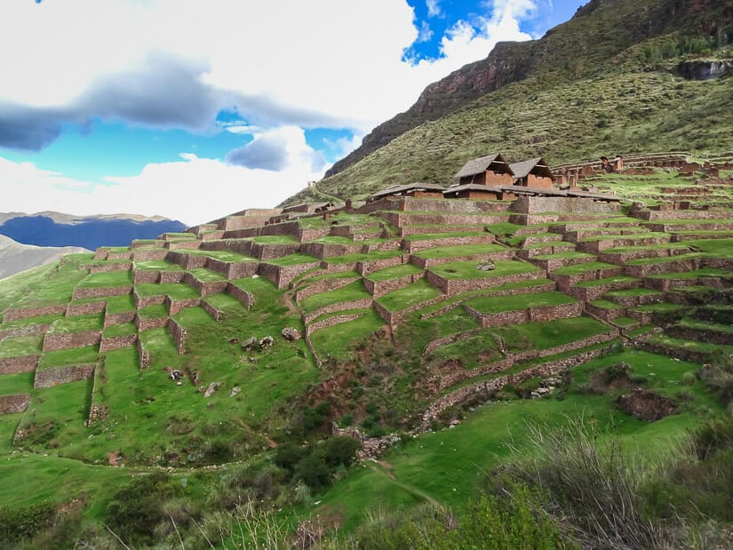
Pumamarka
One of my best days in Ollantaytambo was going on a half-day trip to these remote ruins up a valley northeast of town.
These ruins served as a fortress guarding this entrance to the Sacred Valley. While the ruins themselves didn’t blow me away, it was more the getting there and back that was most interesting. Another highlight is that there are often alpacas in this ruins, as the local farmers let them in to graze.
You could walk all the way to Pumamarca in a couple hours (mostly uphill), although I chose to ride a colectivo there and walk back. The colectivo started here and took 20 minutes. It let me off at a pretty little village called Pallata (ignore the fact that you’ll pass another entrance sign for the ruins – starting from Pallata is better).
From the village, it took me nearly an hour of walking uphill to reach the top of the ruins. The view from the ruins is incredible and there’s usually no one there. The walk back to Ollantaytambo (following the AllTrails map I linked to above) was a lovely 1.5-hour stroll, mostly flat or downhill. There were numerous farms, irrigation canals, beautiful wild flowers, and amazing views for much of the way.
Inti Punku
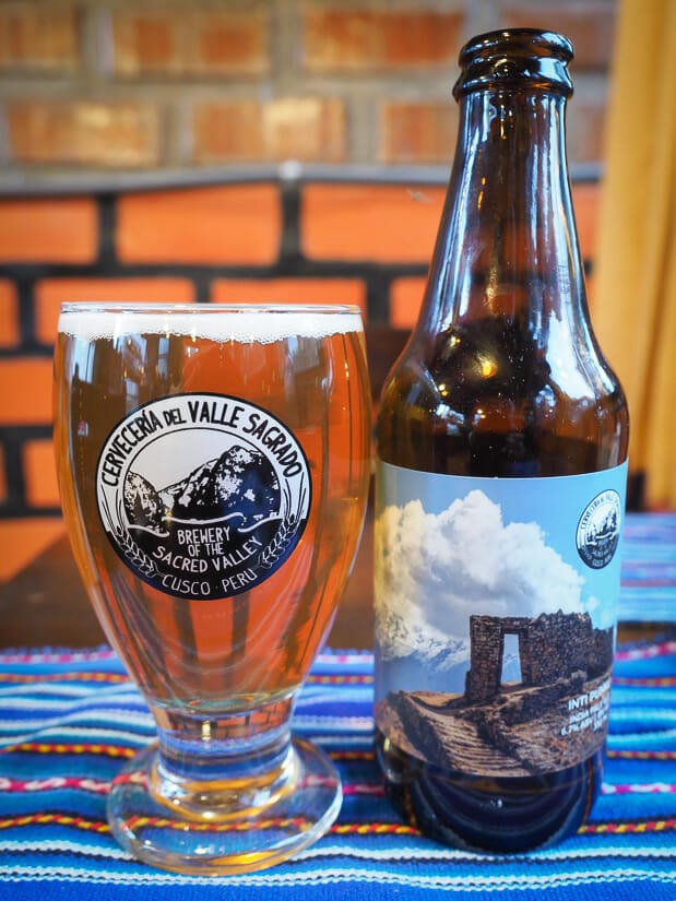
Inti Punku is a high mountain ruin near Ollantaytambo. It is not to be confused with the more famous Inti Punku (Sun Gate) overlooking Machu Picchu ruins.
This one is a set of stairs on a mountaintop, which lead to a doorway that frames a view of sacred Mount Veronika.
A difficult, full-day hike is required to reach this small but iconic ruin. The hike starts at Puente Inca (Inca Bridge, not to be confused with the Machu Picchu Inca Bridge), the bridge across the Urubamba River at the south end of Ollantaytambo town. The trail passes some picturesque Inca quarries along the way.
If you don’t make it to this one, you can do like I did and just enjoy an Inti Punku IPA instead. This is an excellent beer by the Sacred Valley Brewery, and it has a picture of the ruins on the bottle.
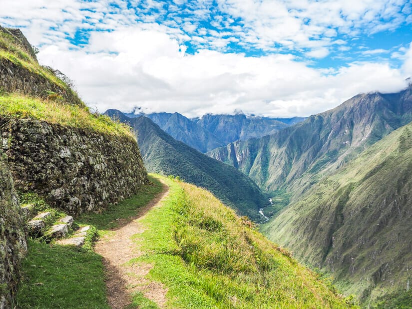
Inca Trail Ruins
It will come as no surprise that some of the best ruins in Cusco region can be found along the Inca Trail. Below are six of the best Inca ruins that you’ll see as you hike the four (or five) day hike to Machu Picchu, in the order that you will see them. If you do the 2-day Inca Trail, you’ll only see the last (but most important) one, Wiñay Wayna.
I’m not going to cover these in as much detail, because the average visitor to Cusco can’t see them unless they hike the Inca Trail.
For more information about Machu Picchu itself, which I won’t cover here, see my detailed guide to the new circuits at Machu Picchu and how to choose the best one.
Patallacta
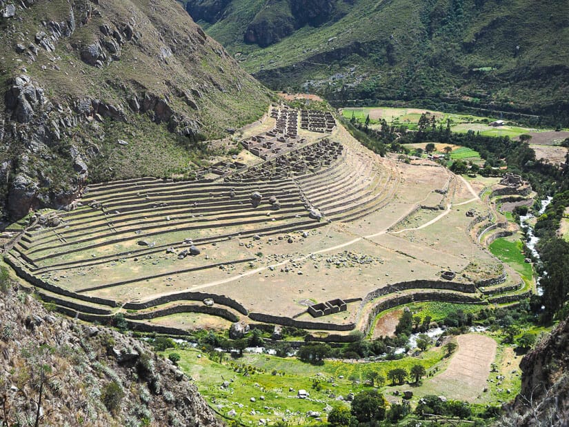
On Day 1 of the Inca Trail, the first and only major Inca ruins that you’ll see are Patallacta. This was an agricultural village that supported Machu Picchu. It has expansive terraces and round temple at the bottom similar to the Torreon (Sun Temple) at Machu Picchu.
You’ll be looking down on these ruins from another set of ruins called Llactapata, which were pre-Inca, dating to the Wari civilization.
Runcuracay
Runcuracay is a some small but unique ruin you’ll see on Day 2 of the Inca Trail. For most people, Day 2 is by far the hardest and longest day of hiking. You start you day by climbing the highest pass of the whole trek, Dead Woman’s Pass (4200 m / 13,780 ft), then descending the other side.
You then climb up the second highest pass of the trek, called Runcuracay. The namesake ruins look like a TV dinner tray – round, with little compartments. A single, very narrow entranceway leads into the ruins. The view from the ruins looking back to Dead Woman’s Pass is epic, when it’s not obscured in clouds.
Sayamarca
Sayamarca ruins are at the end of Day 2 or start of Day 3 for most hikers on the Inca Trail. The name means “inaccessible town”.
This is fitting, as the ruins are accessed by a very narrow and very steep single stone staircase. The ruins seem to perch or hover on the side of a mountain, with various terraces and balconies offering incredible views.
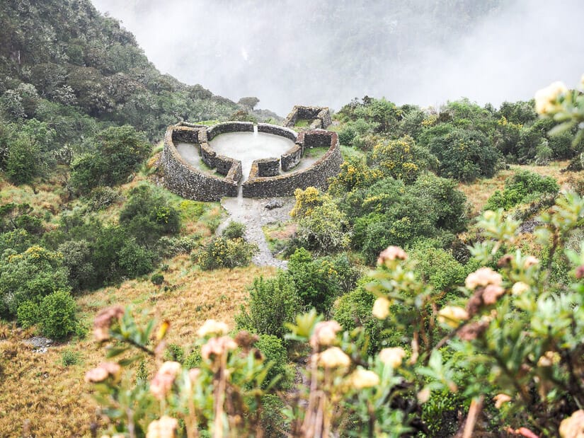
Phuyupatamarca
On Day 3, hikers reach the 3rd highest summit, Phuyupatamarca, with ruins of the same name just below it. The pass offers an epic view looking down on the ruins, Machu Picchu Mountain far below (though you can’t see Machu Picchu ruins yet), and in the other direction, part of Aguas Calientes (Machu Picchu town).
Phuyupatamarca ruins, or “town above the clouds”, are a picturesque site that really is enshrouded in clouds much of the time. The curved walls and geometric terraces blend in with the hillside they’re built on. After this peak and ruins, the Inca Trail descends rapidly towards Machu Picchu and the Amazon forest, rapidly becoming hotter and greener.
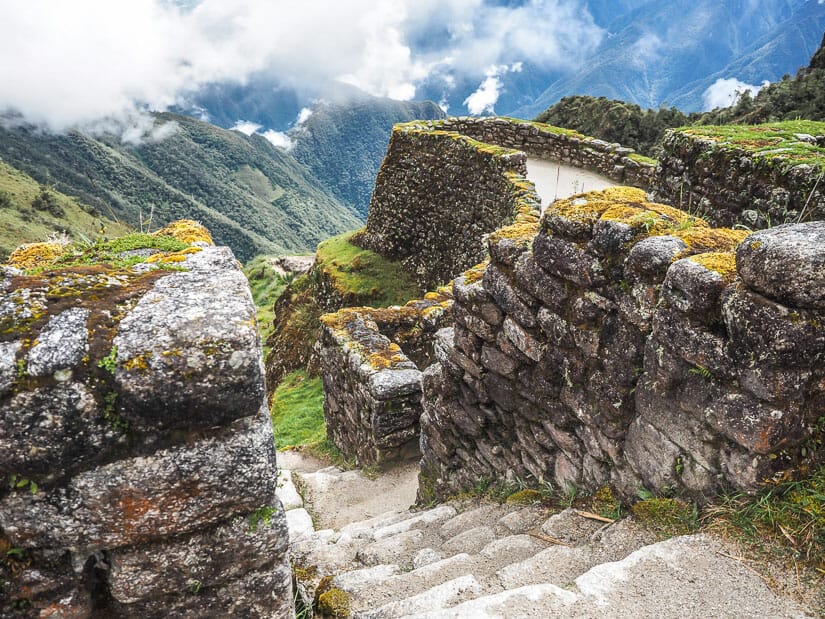
Intipata
The last ruins before trekkers reach their final campsite is Intipata. This is a large collection of very steep terraces. They offer an incredible view of the valley below them and Wiñay Wayna campground area.
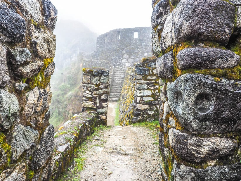
Wiñay Wayna
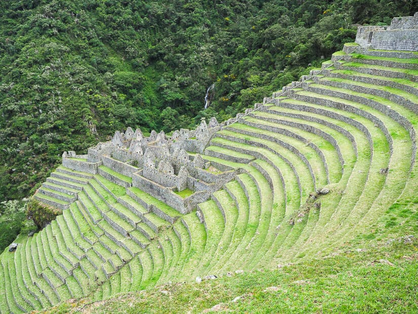
Wiñay Wayna, which means “forever young” and may refer to a small orchid in the area, are the most significant ruins on the Inca Trail besides Machu Picchu itself. You may think I’m crazy for saying this, but I actually enjoyed Wiñay Wayna more than Machu Picchu itself!
Not only are the ruins truly impressive, but I had them entirely to myself when I visited. The ruins are just five minutes from the campsite, but most people were either resting or hadn’t arrived yet when I got to them.
These ruins feature many terraces, an upper elite urban section, a lower section, and a Grand Staircase with 11 fountains stretching between them. From the bottom of the ruins, you can hike to a beautiful waterfall that is also visible from the ruins (see image above). These might just be my favorite ruins in the entire Cusco area!
Ruins West of Cusco
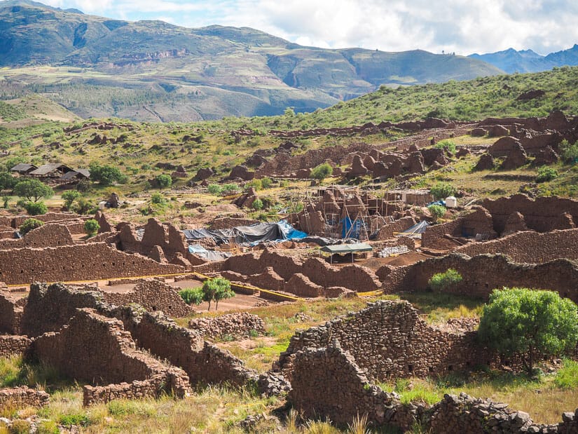
There are a few more difficult-to-reach but extremely important ruins lying in the far west of the Cusco region. I never made it to any of these, but perhaps next time!
Choquequirao
The ruins of Choquequirao are often described as a mini-Machu Picchu or sister to Machu Picchu. This is not to suggest that the ruins are small. In fact, the site spans some 1800 hectares, of which only 30-40% has been excavated so far!
In 2002, 80 new terraces were discovered at Choquequirao, with many white stone llamas built into them. These have since been dubbed the “Llamas del Sol”. The site was likely built by Pachacuti and his son Yupanqui.
Like Machu Picchu, the ruins occupy a saddle between two ridges. It requires 3 to 5 days to trek to it. The hike is harder but not as high altitude as the Inca Trail. However, it is much less popular, so it is considered a great alternative to the Inca Trail.
Vitcos, Espiritu Pampa, and more?
An even less visited but very important Inca archaeological site west of Cusco is Vitcos. I only learned about this site by reading Turn Right at Machu Picchu, an excellent read that retraces the steps of Hiram Bingham, the scientific discoverer of Machu Picchu.
Vitcos is where the Inca Manco retreated to aftert the Spanish eventually took Ollantaytambo. The ruins today are not especially impressive nor are they easy to get to, so they are seldom visited.
Empiritu Pampa is the modern name for Vilcabamba, some ruins that are even deeper in the jungle. Although Bingham didn’t realize it when he first discovered them, this was in fact the “Lost City of the Incas”, the final holdout of Manco Inca. The archaeological site is deep in the jungle. It is very rarely and not easily visited by travelers. But historically it is very important and still under excavation.
As for the “more?”, well, who knows what else lies out there! There may be even more Inca ruins around Cusco just waiting to be discovered. If I missed any Cusco ruins that you think are a must, please mention them in the comments below!